You are here: Home > Network List > CI - Caltech Regional Seismic Network Stations List
> Station TUQ Turquiose Mountain, Baker, CA, USA > Earthquake Result Viewer
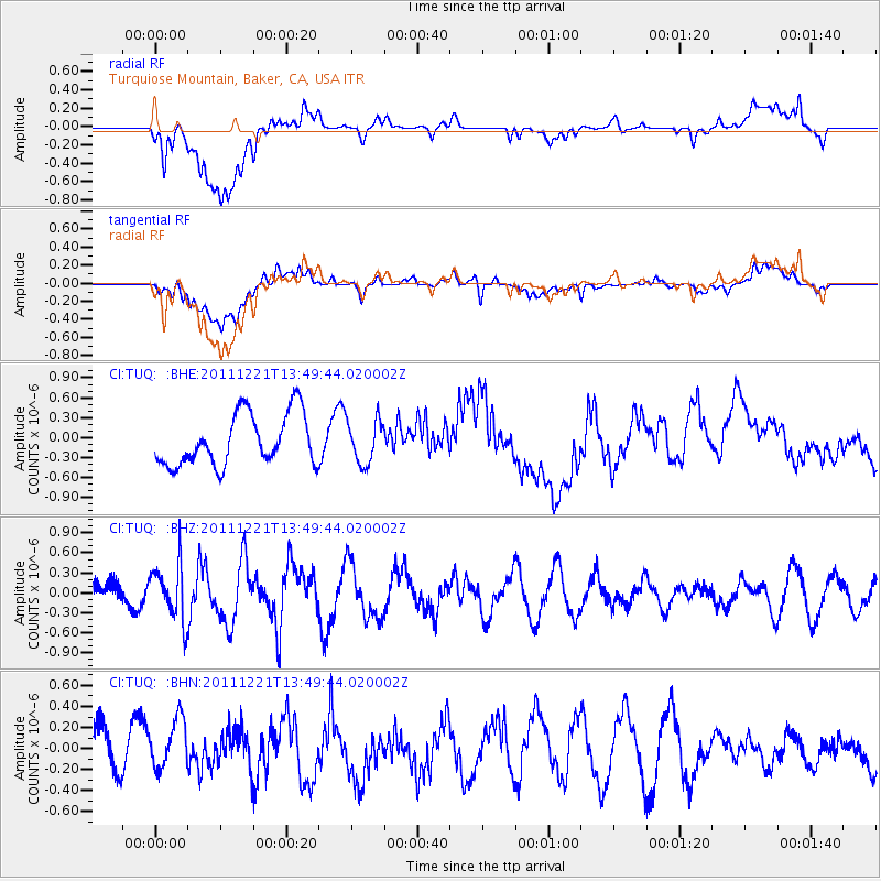
TUQ Turquiose Mountain, Baker, CA, USA - Earthquake Result Viewer
*The percent match for this event was below the threshold and hence no stack was calculated.
| Earthquake location: |
South Of Kermadec Islands |
| Earthquake latitude/longitude: |
-33.2/-179.0 |
| Earthquake time(UTC): |
2011/12/21 (355) 13:37:14 GMT |
| Earthquake Depth: |
10 km |
| Earthquake Magnitude: |
5.6 MB, 5.4 MS, 5.5 MW, 5.7 MW |
| Earthquake Catalog/Contributor: |
WHDF/NEIC |
|
| Network: |
CI Caltech Regional Seismic Network |
| Station: |
TUQ Turquiose Mountain, Baker, CA, USA |
| Lat/Lon: |
35.44 N/115.92 W |
| Elevation: |
1350 m |
|
| Distance: |
90.3 deg |
| Az: |
46.736 deg |
| Baz: |
228.412 deg |
| Ray Param: |
$rayparam |
*The percent match for this event was below the threshold and hence was not used in the summary stack. |
|
| Radial Match: |
61.611313 % |
| Radial Bump: |
400 |
| Transverse Match: |
52.60384 % |
| Transverse Bump: |
400 |
| SOD ConfigId: |
434841 |
| Insert Time: |
2012-03-13 20:49:01.192 +0000 |
| GWidth: |
2.5 |
| Max Bumps: |
400 |
| Tol: |
0.001 |
|
Signal To Noise
| Channel | StoN | STA | LTA |
| CI:TUQ: :BHZ:20111221T13:49:44.020002Z | 1.7780857 | 4.1593256E-7 | 2.3392155E-7 |
| CI:TUQ: :BHN:20111221T13:49:44.020002Z | 1.4445701 | 2.4096792E-7 | 1.6680943E-7 |
| CI:TUQ: :BHE:20111221T13:49:44.020002Z | 0.83762574 | 3.2167551E-7 | 3.8403252E-7 |
| Arrivals |
| Ps | |
| PpPs | |
| PsPs/PpSs | |


