You are here: Home > Network List > UW - Pacific Northwest Regional Seismic Network Stations List
> Station PASS Maple Falls, WA, USA > Earthquake Result Viewer
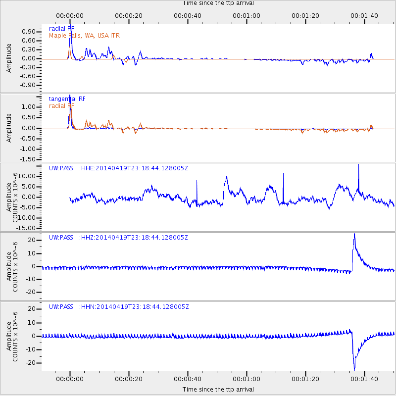
PASS Maple Falls, WA, USA - Earthquake Result Viewer
*The percent match for this event was below the threshold and hence no stack was calculated.
| Earthquake location: |
Solomon Islands |
| Earthquake latitude/longitude: |
-7.0/155.1 |
| Earthquake time(UTC): |
2014/04/19 (109) 23:06:17 GMT |
| Earthquake Depth: |
41 km |
| Earthquake Magnitude: |
5.5 MW |
| Earthquake Catalog/Contributor: |
ISC/ISC |
|
| Network: |
UW Pacific Northwest Regional Seismic Network |
| Station: |
PASS Maple Falls, WA, USA |
| Lat/Lon: |
49.00 N/122.09 W |
| Elevation: |
174 m |
|
| Distance: |
90.6 deg |
| Az: |
40.807 deg |
| Baz: |
260.068 deg |
| Ray Param: |
$rayparam |
*The percent match for this event was below the threshold and hence was not used in the summary stack. |
|
| Radial Match: |
58.56091 % |
| Radial Bump: |
272 |
| Transverse Match: |
97.71895 % |
| Transverse Bump: |
83 |
| SOD ConfigId: |
3390531 |
| Insert Time: |
2019-04-11 12:52:28.489 +0000 |
| GWidth: |
2.5 |
| Max Bumps: |
400 |
| Tol: |
0.001 |
|
Signal To Noise
| Channel | StoN | STA | LTA |
| UW:PASS: :HHZ:20140419T23:18:44.128005Z | 1.1227181 | 8.0262873E-7 | 7.1489785E-7 |
| UW:PASS: :HHN:20140419T23:18:44.128005Z | 1.0998007 | 8.79242E-7 | 7.9945573E-7 |
| UW:PASS: :HHE:20140419T23:18:44.128005Z | 1.9836177 | 2.1362728E-6 | 1.0769579E-6 |
| Arrivals |
| Ps | |
| PpPs | |
| PsPs/PpSs | |


