You are here: Home > Network List > G - GEOSCOPE Stations List
> Station HYB Hyderabad, India > Earthquake Result Viewer
HYB Hyderabad, India - Earthquake Result Viewer

| Earthquake location: |
Banda Sea |
| Earthquake latitude/longitude: |
-4.1/127.4 |
| Earthquake time(UTC): |
2000/08/28 (241) 15:05:47 GMT |
| Earthquake Depth: |
16 km |
| Earthquake Magnitude: |
6.5 MB, 6.8 MS, 6.8 MW, 6.7 ME |
| Earthquake Catalog/Contributor: |
WHDF/NEIC |
|
| Network: |
G GEOSCOPE |
| Station: |
HYB Hyderabad, India |
| Lat/Lon: |
17.42 N/78.55 E |
| Elevation: |
510 m |
|
| Distance: |
52.7 deg |
| Az: |
295.411 deg |
| Baz: |
109.319 deg |
| Ray Param: |
0.06655838 |
| Estimated Moho Depth: |
32.25 km |
| Estimated Crust Vp/Vs: |
1.79 |
| Assumed Crust Vp: |
6.459 km/s |
| Estimated Crust Vs: |
3.619 km/s |
| Estimated Crust Poisson's Ratio: |
0.27 |
|
| Radial Match: |
97.71999 % |
| Radial Bump: |
246 |
| Transverse Match: |
80.20046 % |
| Transverse Bump: |
400 |
| SOD ConfigId: |
3744 |
| Insert Time: |
2010-02-26 23:00:18.621 +0000 |
| GWidth: |
2.5 |
| Max Bumps: |
400 |
| Tol: |
0.001 |
|
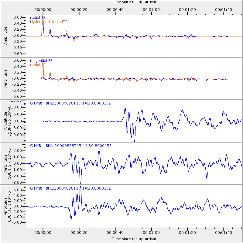
Signal To Noise
| Channel | StoN | STA | LTA |
| G:HYB: :BHN:20000828T15:14:30.800015Z | 1.0507627 | 2.2689207E-7 | 2.1593084E-7 |
| G:HYB: :BHE:20000828T15:14:30.800015Z | 1.490705 | 1.898041E-7 | 1.2732505E-7 |
| G:HYB: :BHZ:20000828T15:14:30.800015Z | 0.70193833 | 1.9037888E-7 | 2.712188E-7 |
| Arrivals |
| Ps | 4.1 SECOND |
| PpPs | 13 SECOND |
| PsPs/PpSs | 17 SECOND |


