You are here: Home > Network List > IW - Intermountain West Stations List
> Station IMW Indian Meadow, Wyoming, USA > Earthquake Result Viewer
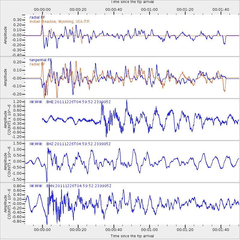
IMW Indian Meadow, Wyoming, USA - Earthquake Result Viewer
*The percent match for this event was below the threshold and hence no stack was calculated.
| Earthquake location: |
Tonga Islands |
| Earthquake latitude/longitude: |
-16.2/-173.9 |
| Earthquake time(UTC): |
2011/12/26 (360) 04:48:08 GMT |
| Earthquake Depth: |
90 km |
| Earthquake Magnitude: |
5.8 MB, 6.0 MW, 6.0 MW |
| Earthquake Catalog/Contributor: |
WHDF/NEIC |
|
| Network: |
IW Intermountain West |
| Station: |
IMW Indian Meadow, Wyoming, USA |
| Lat/Lon: |
43.90 N/110.94 W |
| Elevation: |
2646 m |
|
| Distance: |
82.8 deg |
| Az: |
40.446 deg |
| Baz: |
239.566 deg |
| Ray Param: |
$rayparam |
*The percent match for this event was below the threshold and hence was not used in the summary stack. |
|
| Radial Match: |
75.25015 % |
| Radial Bump: |
400 |
| Transverse Match: |
63.018356 % |
| Transverse Bump: |
400 |
| SOD ConfigId: |
434841 |
| Insert Time: |
2012-03-15 04:37:13.351 +0000 |
| GWidth: |
2.5 |
| Max Bumps: |
400 |
| Tol: |
0.001 |
|
Signal To Noise
| Channel | StoN | STA | LTA |
| IW:IMW: :BHZ:20111226T04:59:52.239995Z | 5.905038 | 7.19546E-7 | 1.2185289E-7 |
| IW:IMW: :BHN:20111226T04:59:52.239995Z | 2.068157 | 4.010335E-7 | 1.9390863E-7 |
| IW:IMW: :BHE:20111226T04:59:52.239995Z | 3.3261316 | 4.203364E-7 | 1.2637396E-7 |
| Arrivals |
| Ps | |
| PpPs | |
| PsPs/PpSs | |


