You are here: Home > Network List > UW - Pacific Northwest Regional Seismic Network Stations List
> Station MRBL Marblemount, WA, USA > Earthquake Result Viewer
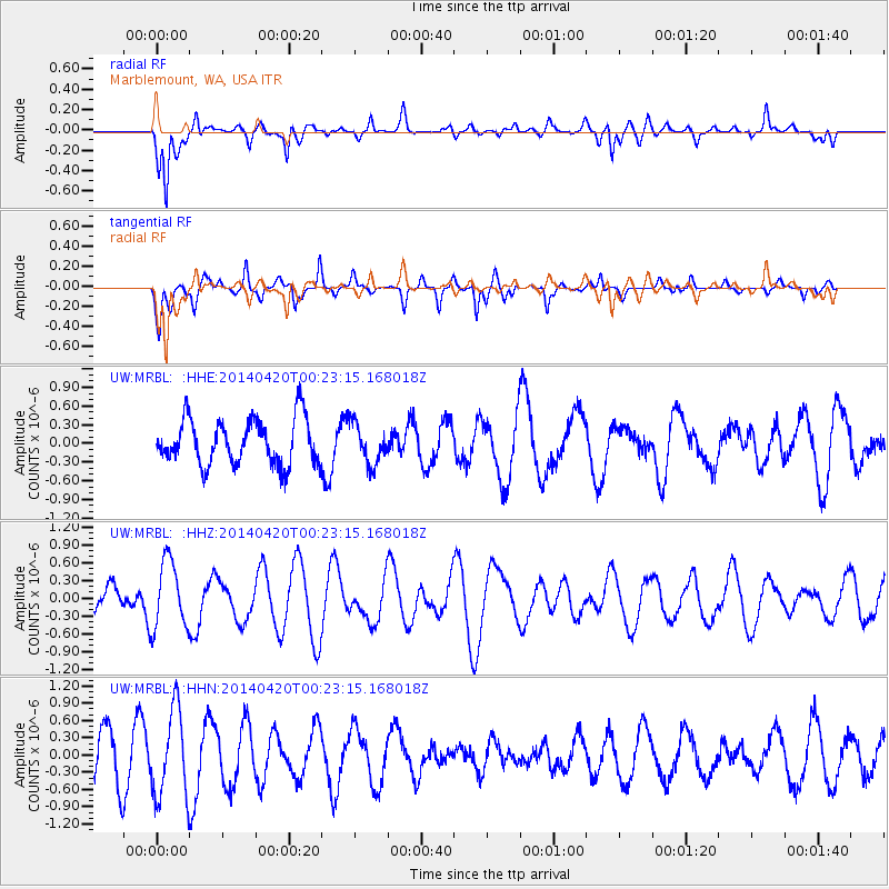
MRBL Marblemount, WA, USA - Earthquake Result Viewer
*The percent match for this event was below the threshold and hence no stack was calculated.
| Earthquake location: |
Solomon Islands |
| Earthquake latitude/longitude: |
-7.1/155.3 |
| Earthquake time(UTC): |
2014/04/20 (110) 00:10:45 GMT |
| Earthquake Depth: |
24 km |
| Earthquake Magnitude: |
5.2 mb |
| Earthquake Catalog/Contributor: |
ISC/ISC |
|
| Network: |
UW Pacific Northwest Regional Seismic Network |
| Station: |
MRBL Marblemount, WA, USA |
| Lat/Lon: |
48.52 N/121.48 W |
| Elevation: |
75 m |
|
| Distance: |
90.8 deg |
| Az: |
41.319 deg |
| Baz: |
260.246 deg |
| Ray Param: |
$rayparam |
*The percent match for this event was below the threshold and hence was not used in the summary stack. |
|
| Radial Match: |
81.017044 % |
| Radial Bump: |
400 |
| Transverse Match: |
75.56576 % |
| Transverse Bump: |
400 |
| SOD ConfigId: |
3390531 |
| Insert Time: |
2019-04-11 12:56:37.046 +0000 |
| GWidth: |
2.5 |
| Max Bumps: |
400 |
| Tol: |
0.001 |
|
Signal To Noise
| Channel | StoN | STA | LTA |
| UW:MRBL: :HHZ:20140420T00:23:15.168018Z | 1.3380443 | 5.7477206E-7 | 4.295613E-7 |
| UW:MRBL: :HHN:20140420T00:23:15.168018Z | 1.8356534 | 7.585523E-7 | 4.1323284E-7 |
| UW:MRBL: :HHE:20140420T00:23:15.168018Z | 0.8910134 | 3.2308213E-7 | 3.6260076E-7 |
| Arrivals |
| Ps | |
| PpPs | |
| PsPs/PpSs | |


