You are here: Home > Network List > TA - USArray Transportable Network (new EarthScope stations) Stations List
> Station J05D Fort Rock, OR, USA > Earthquake Result Viewer
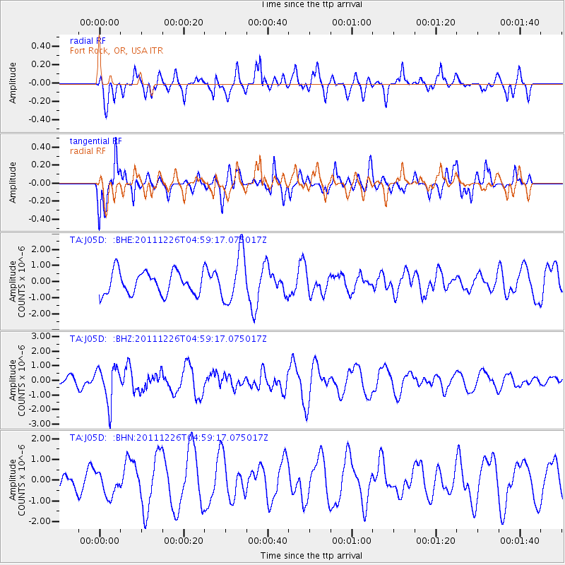
J05D Fort Rock, OR, USA - Earthquake Result Viewer
*The percent match for this event was below the threshold and hence no stack was calculated.
| Earthquake location: |
Tonga Islands |
| Earthquake latitude/longitude: |
-16.2/-173.9 |
| Earthquake time(UTC): |
2011/12/26 (360) 04:48:08 GMT |
| Earthquake Depth: |
90 km |
| Earthquake Magnitude: |
5.8 MB, 6.0 MW, 6.0 MW |
| Earthquake Catalog/Contributor: |
WHDF/NEIC |
|
| Network: |
TA USArray Transportable Network (new EarthScope stations) |
| Station: |
J05D Fort Rock, OR, USA |
| Lat/Lon: |
43.28 N/121.23 W |
| Elevation: |
1541 m |
|
| Distance: |
76.3 deg |
| Az: |
36.675 deg |
| Baz: |
231.799 deg |
| Ray Param: |
$rayparam |
*The percent match for this event was below the threshold and hence was not used in the summary stack. |
|
| Radial Match: |
53.27309 % |
| Radial Bump: |
400 |
| Transverse Match: |
64.37133 % |
| Transverse Bump: |
376 |
| SOD ConfigId: |
434841 |
| Insert Time: |
2012-03-15 04:41:28.272 +0000 |
| GWidth: |
2.5 |
| Max Bumps: |
400 |
| Tol: |
0.001 |
|
Signal To Noise
| Channel | StoN | STA | LTA |
| TA:J05D: :BHZ:20111226T04:59:17.075017Z | 3.014518 | 1.2746515E-6 | 4.228376E-7 |
| TA:J05D: :BHN:20111226T04:59:17.075017Z | 0.7830411 | 5.5912346E-7 | 7.14041E-7 |
| TA:J05D: :BHE:20111226T04:59:17.075017Z | 2.290266 | 1.5963363E-6 | 6.970091E-7 |
| Arrivals |
| Ps | |
| PpPs | |
| PsPs/PpSs | |


