You are here: Home > Network List > TA - USArray Transportable Network (new EarthScope stations) Stations List
> Station N02D Trinity Center, CA, USA > Earthquake Result Viewer
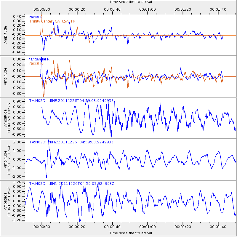
N02D Trinity Center, CA, USA - Earthquake Result Viewer
*The percent match for this event was below the threshold and hence no stack was calculated.
| Earthquake location: |
Tonga Islands |
| Earthquake latitude/longitude: |
-16.2/-173.9 |
| Earthquake time(UTC): |
2011/12/26 (360) 04:48:08 GMT |
| Earthquake Depth: |
90 km |
| Earthquake Magnitude: |
5.8 MB, 6.0 MW, 6.0 MW |
| Earthquake Catalog/Contributor: |
WHDF/NEIC |
|
| Network: |
TA USArray Transportable Network (new EarthScope stations) |
| Station: |
N02D Trinity Center, CA, USA |
| Lat/Lon: |
40.97 N/122.71 W |
| Elevation: |
937 m |
|
| Distance: |
74.0 deg |
| Az: |
37.838 deg |
| Baz: |
231.114 deg |
| Ray Param: |
$rayparam |
*The percent match for this event was below the threshold and hence was not used in the summary stack. |
|
| Radial Match: |
66.24797 % |
| Radial Bump: |
400 |
| Transverse Match: |
62.14019 % |
| Transverse Bump: |
400 |
| SOD ConfigId: |
434841 |
| Insert Time: |
2012-03-15 04:41:43.285 +0000 |
| GWidth: |
2.5 |
| Max Bumps: |
400 |
| Tol: |
0.001 |
|
Signal To Noise
| Channel | StoN | STA | LTA |
| TA:N02D: :BHZ:20111226T04:59:03.924993Z | 1.6172028 | 1.0179951E-6 | 6.2947896E-7 |
| TA:N02D: :BHN:20111226T04:59:03.924993Z | 0.719003 | 4.996774E-7 | 6.9495866E-7 |
| TA:N02D: :BHE:20111226T04:59:03.924993Z | 1.482975 | 5.271698E-7 | 3.5548123E-7 |
| Arrivals |
| Ps | |
| PpPs | |
| PsPs/PpSs | |


