You are here: Home > Network List > TA - USArray Transportable Network (new EarthScope stations) Stations List
> Station Y12C Blythe, CA, USA > Earthquake Result Viewer
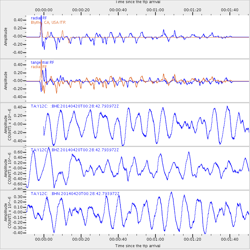
Y12C Blythe, CA, USA - Earthquake Result Viewer
*The percent match for this event was below the threshold and hence no stack was calculated.
| Earthquake location: |
Solomon Islands |
| Earthquake latitude/longitude: |
-7.2/155.3 |
| Earthquake time(UTC): |
2014/04/20 (110) 00:15:58 GMT |
| Earthquake Depth: |
18 km |
| Earthquake Magnitude: |
6.1 MWP |
| Earthquake Catalog/Contributor: |
NEIC PDE/NEIC COMCAT |
|
| Network: |
TA USArray Transportable Network (new EarthScope stations) |
| Station: |
Y12C Blythe, CA, USA |
| Lat/Lon: |
33.75 N/114.52 W |
| Elevation: |
196 m |
|
| Distance: |
94.1 deg |
| Az: |
56.645 deg |
| Baz: |
264.149 deg |
| Ray Param: |
$rayparam |
*The percent match for this event was below the threshold and hence was not used in the summary stack. |
|
| Radial Match: |
63.47402 % |
| Radial Bump: |
400 |
| Transverse Match: |
67.34654 % |
| Transverse Bump: |
400 |
| SOD ConfigId: |
3390531 |
| Insert Time: |
2019-04-11 12:59:40.093 +0000 |
| GWidth: |
2.5 |
| Max Bumps: |
400 |
| Tol: |
0.001 |
|
Signal To Noise
| Channel | StoN | STA | LTA |
| TA:Y12C: :BHZ:20140420T00:28:42.793972Z | 1.2974019 | 4.4487047E-7 | 3.4289334E-7 |
| TA:Y12C: :BHN:20140420T00:28:42.793972Z | 1.1537541 | 1.6757635E-7 | 1.4524443E-7 |
| TA:Y12C: :BHE:20140420T00:28:42.793972Z | 0.8324086 | 1.9968755E-7 | 2.3989125E-7 |
| Arrivals |
| Ps | |
| PpPs | |
| PsPs/PpSs | |


