You are here: Home > Network List > TA - USArray Transportable Network (new EarthScope stations) Stations List
> Station J38A Wedel Dairy, Riceville, IA, USA > Earthquake Result Viewer
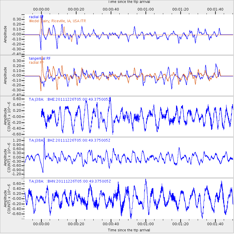
J38A Wedel Dairy, Riceville, IA, USA - Earthquake Result Viewer
*The percent match for this event was below the threshold and hence no stack was calculated.
| Earthquake location: |
Tonga Islands |
| Earthquake latitude/longitude: |
-16.2/-173.9 |
| Earthquake time(UTC): |
2011/12/26 (360) 04:48:08 GMT |
| Earthquake Depth: |
90 km |
| Earthquake Magnitude: |
5.8 MB, 6.0 MW, 6.0 MW |
| Earthquake Catalog/Contributor: |
WHDF/NEIC |
|
| Network: |
TA USArray Transportable Network (new EarthScope stations) |
| Station: |
J38A Wedel Dairy, Riceville, IA, USA |
| Lat/Lon: |
43.32 N/92.48 W |
| Elevation: |
371 m |
|
| Distance: |
94.8 deg |
| Az: |
46.402 deg |
| Baz: |
252.435 deg |
| Ray Param: |
$rayparam |
*The percent match for this event was below the threshold and hence was not used in the summary stack. |
|
| Radial Match: |
61.9725 % |
| Radial Bump: |
400 |
| Transverse Match: |
61.902294 % |
| Transverse Bump: |
399 |
| SOD ConfigId: |
434841 |
| Insert Time: |
2012-03-15 04:47:28.231 +0000 |
| GWidth: |
2.5 |
| Max Bumps: |
400 |
| Tol: |
0.001 |
|
Signal To Noise
| Channel | StoN | STA | LTA |
| TA:J38A: :BHZ:20111226T05:00:49.375005Z | 2.6106393 | 5.291387E-7 | 2.0268547E-7 |
| TA:J38A: :BHN:20111226T05:00:49.375005Z | 0.84112185 | 2.1543495E-7 | 2.5612812E-7 |
| TA:J38A: :BHE:20111226T05:00:49.375005Z | 0.9279527 | 2.2424688E-7 | 2.4165766E-7 |
| Arrivals |
| Ps | |
| PpPs | |
| PsPs/PpSs | |


