You are here: Home > Network List > TA - USArray Transportable Network (new EarthScope stations) Stations List
> Station Z43A Armstrong Family, Eudora, AR, USA > Earthquake Result Viewer
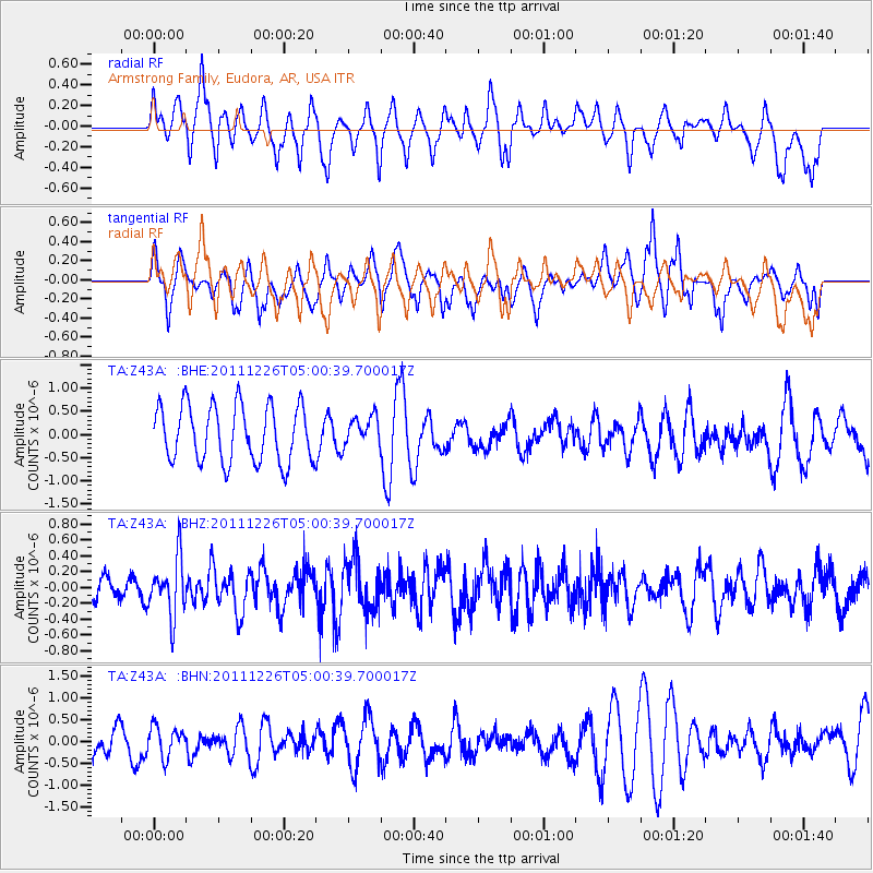
Z43A Armstrong Family, Eudora, AR, USA - Earthquake Result Viewer
*The percent match for this event was below the threshold and hence no stack was calculated.
| Earthquake location: |
Tonga Islands |
| Earthquake latitude/longitude: |
-16.2/-173.9 |
| Earthquake time(UTC): |
2011/12/26 (360) 04:48:08 GMT |
| Earthquake Depth: |
90 km |
| Earthquake Magnitude: |
5.8 MB, 6.0 MW, 6.0 MW |
| Earthquake Catalog/Contributor: |
WHDF/NEIC |
|
| Network: |
TA USArray Transportable Network (new EarthScope stations) |
| Station: |
Z43A Armstrong Family, Eudora, AR, USA |
| Lat/Lon: |
33.21 N/91.24 W |
| Elevation: |
39 m |
|
| Distance: |
92.7 deg |
| Az: |
56.34 deg |
| Baz: |
252.539 deg |
| Ray Param: |
$rayparam |
*The percent match for this event was below the threshold and hence was not used in the summary stack. |
|
| Radial Match: |
58.355488 % |
| Radial Bump: |
400 |
| Transverse Match: |
49.988003 % |
| Transverse Bump: |
381 |
| SOD ConfigId: |
434841 |
| Insert Time: |
2012-03-15 04:50:05.301 +0000 |
| GWidth: |
2.5 |
| Max Bumps: |
400 |
| Tol: |
0.001 |
|
Signal To Noise
| Channel | StoN | STA | LTA |
| TA:Z43A: :BHZ:20111226T05:00:39.700017Z | 3.0078778 | 3.5730451E-7 | 1.18789565E-7 |
| TA:Z43A: :BHN:20111226T05:00:39.700017Z | 0.8093483 | 3.3408287E-7 | 4.1278008E-7 |
| TA:Z43A: :BHE:20111226T05:00:39.700017Z | 0.52194244 | 3.1582707E-7 | 6.0509944E-7 |
| Arrivals |
| Ps | |
| PpPs | |
| PsPs/PpSs | |


