You are here: Home > Network List > TA - USArray Transportable Network (new EarthScope stations) Stations List
> Station X44A Crenshaw, MS, USA > Earthquake Result Viewer
X44A Crenshaw, MS, USA - Earthquake Result Viewer
*The percent match for this event was below the threshold and hence no stack was calculated.
| Earthquake location: |
Tonga Islands |
| Earthquake latitude/longitude: |
-16.2/-173.9 |
| Earthquake time(UTC): |
2011/12/26 (360) 04:48:08 GMT |
| Earthquake Depth: |
90 km |
| Earthquake Magnitude: |
5.8 MB, 6.0 MW, 6.0 MW |
| Earthquake Catalog/Contributor: |
WHDF/NEIC |
|
| Network: |
TA USArray Transportable Network (new EarthScope stations) |
| Station: |
X44A Crenshaw, MS, USA |
| Lat/Lon: |
34.50 N/90.15 W |
| Elevation: |
109 m |
|
| Distance: |
94.0 deg |
| Az: |
55.378 deg |
| Baz: |
253.204 deg |
| Ray Param: |
$rayparam |
*The percent match for this event was below the threshold and hence was not used in the summary stack. |
|
| Radial Match: |
45.698452 % |
| Radial Bump: |
334 |
| Transverse Match: |
57.34282 % |
| Transverse Bump: |
369 |
| SOD ConfigId: |
434841 |
| Insert Time: |
2012-03-15 04:50:32.284 +0000 |
| GWidth: |
2.5 |
| Max Bumps: |
400 |
| Tol: |
0.001 |
|
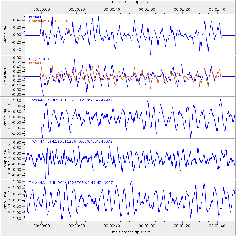
Signal To Noise
| Channel | StoN | STA | LTA |
| TA:X44A: :BHZ:20111226T05:00:45.424993Z | 2.1003773 | 4.530625E-7 | 2.157053E-7 |
| TA:X44A: :BHN:20111226T05:00:45.424993Z | 0.9407314 | 6.578634E-7 | 6.9931053E-7 |
| TA:X44A: :BHE:20111226T05:00:45.424993Z | 0.5905005 | 3.9496413E-7 | 6.688634E-7 |
| Arrivals |
| Ps | |
| PpPs | |
| PsPs/PpSs | |


