You are here: Home > Network List > TA - USArray Transportable Network (new EarthScope stations) Stations List
> Station Q43A New Douglas, IL, USA > Earthquake Result Viewer
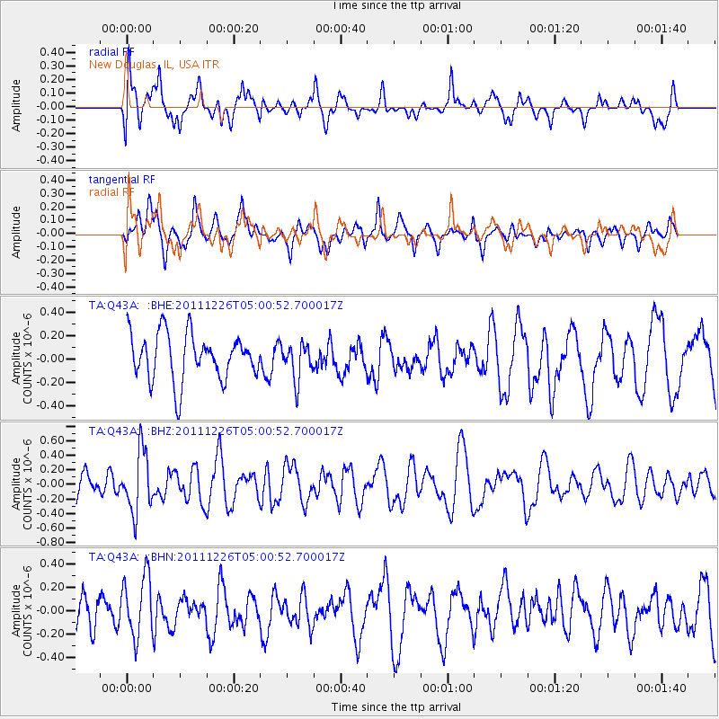
Q43A New Douglas, IL, USA - Earthquake Result Viewer
*The percent match for this event was below the threshold and hence no stack was calculated.
| Earthquake location: |
Tonga Islands |
| Earthquake latitude/longitude: |
-16.2/-173.9 |
| Earthquake time(UTC): |
2011/12/26 (360) 04:48:08 GMT |
| Earthquake Depth: |
90 km |
| Earthquake Magnitude: |
5.8 MB, 6.0 MW, 6.0 MW |
| Earthquake Catalog/Contributor: |
WHDF/NEIC |
|
| Network: |
TA USArray Transportable Network (new EarthScope stations) |
| Station: |
Q43A New Douglas, IL, USA |
| Lat/Lon: |
38.94 N/89.70 W |
| Elevation: |
202 m |
|
| Distance: |
95.6 deg |
| Az: |
51.216 deg |
| Baz: |
253.818 deg |
| Ray Param: |
$rayparam |
*The percent match for this event was below the threshold and hence was not used in the summary stack. |
|
| Radial Match: |
66.200294 % |
| Radial Bump: |
400 |
| Transverse Match: |
64.26034 % |
| Transverse Bump: |
400 |
| SOD ConfigId: |
434841 |
| Insert Time: |
2012-03-15 04:50:54.764 +0000 |
| GWidth: |
2.5 |
| Max Bumps: |
400 |
| Tol: |
0.001 |
|
Signal To Noise
| Channel | StoN | STA | LTA |
| TA:Q43A: :BHZ:20111226T05:00:52.700017Z | 2.6061983 | 4.219347E-7 | 1.6189662E-7 |
| TA:Q43A: :BHN:20111226T05:00:52.700017Z | 1.5732971 | 2.621154E-7 | 1.666026E-7 |
| TA:Q43A: :BHE:20111226T05:00:52.700017Z | 0.7764134 | 1.5538802E-7 | 2.0013569E-7 |
| Arrivals |
| Ps | |
| PpPs | |
| PsPs/PpSs | |


