You are here: Home > Network List > TA - USArray Transportable Network (new EarthScope stations) Stations List
> Station J41A Loganville, WI, USA > Earthquake Result Viewer
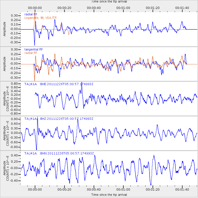
J41A Loganville, WI, USA - Earthquake Result Viewer
*The percent match for this event was below the threshold and hence no stack was calculated.
| Earthquake location: |
Tonga Islands |
| Earthquake latitude/longitude: |
-16.2/-173.9 |
| Earthquake time(UTC): |
2011/12/26 (360) 04:48:08 GMT |
| Earthquake Depth: |
90 km |
| Earthquake Magnitude: |
5.8 MB, 6.0 MW, 6.0 MW |
| Earthquake Catalog/Contributor: |
WHDF/NEIC |
|
| Network: |
TA USArray Transportable Network (new EarthScope stations) |
| Station: |
J41A Loganville, WI, USA |
| Lat/Lon: |
43.37 N/90.01 W |
| Elevation: |
360 m |
|
| Distance: |
96.6 deg |
| Az: |
46.878 deg |
| Baz: |
254.071 deg |
| Ray Param: |
$rayparam |
*The percent match for this event was below the threshold and hence was not used in the summary stack. |
|
| Radial Match: |
56.49587 % |
| Radial Bump: |
400 |
| Transverse Match: |
69.47873 % |
| Transverse Bump: |
400 |
| SOD ConfigId: |
434841 |
| Insert Time: |
2012-03-15 04:51:12.341 +0000 |
| GWidth: |
2.5 |
| Max Bumps: |
400 |
| Tol: |
0.001 |
|
Signal To Noise
| Channel | StoN | STA | LTA |
| TA:J41A: :BHZ:20111226T05:00:57.174993Z | 1.7085949 | 4.296741E-7 | 2.5147804E-7 |
| TA:J41A: :BHN:20111226T05:00:57.174993Z | 0.87008584 | 1.1618198E-7 | 1.3352933E-7 |
| TA:J41A: :BHE:20111226T05:00:57.174993Z | 1.6141526 | 3.7061128E-7 | 2.2960116E-7 |
| Arrivals |
| Ps | |
| PpPs | |
| PsPs/PpSs | |


