You are here: Home > Network List > TA - USArray Transportable Network (new EarthScope stations) Stations List
> Station U41A Viola, AR, USA > Earthquake Result Viewer
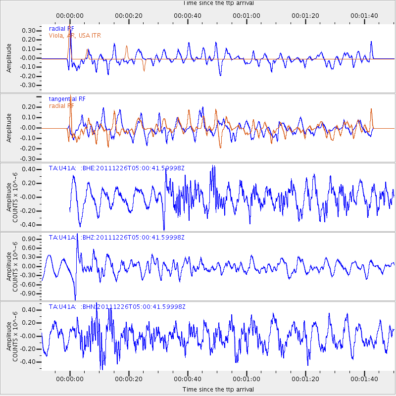
U41A Viola, AR, USA - Earthquake Result Viewer
*The percent match for this event was below the threshold and hence no stack was calculated.
| Earthquake location: |
Tonga Islands |
| Earthquake latitude/longitude: |
-16.2/-173.9 |
| Earthquake time(UTC): |
2011/12/26 (360) 04:48:08 GMT |
| Earthquake Depth: |
90 km |
| Earthquake Magnitude: |
5.8 MB, 6.0 MW, 6.0 MW |
| Earthquake Catalog/Contributor: |
WHDF/NEIC |
|
| Network: |
TA USArray Transportable Network (new EarthScope stations) |
| Station: |
U41A Viola, AR, USA |
| Lat/Lon: |
36.34 N/91.92 W |
| Elevation: |
300 m |
|
| Distance: |
93.1 deg |
| Az: |
53.187 deg |
| Baz: |
252.317 deg |
| Ray Param: |
$rayparam |
*The percent match for this event was below the threshold and hence was not used in the summary stack. |
|
| Radial Match: |
60.40604 % |
| Radial Bump: |
400 |
| Transverse Match: |
66.341995 % |
| Transverse Bump: |
400 |
| SOD ConfigId: |
434841 |
| Insert Time: |
2012-03-15 04:51:41.867 +0000 |
| GWidth: |
2.5 |
| Max Bumps: |
400 |
| Tol: |
0.001 |
|
Signal To Noise
| Channel | StoN | STA | LTA |
| TA:U41A: :BHZ:20111226T05:00:41.59998Z | 2.065303 | 4.6303145E-7 | 2.2419542E-7 |
| TA:U41A: :BHN:20111226T05:00:41.59998Z | 1.1899872 | 1.4651775E-7 | 1.2312547E-7 |
| TA:U41A: :BHE:20111226T05:00:41.59998Z | 1.2444643 | 1.898764E-7 | 1.5257682E-7 |
| Arrivals |
| Ps | |
| PpPs | |
| PsPs/PpSs | |


