You are here: Home > Network List > TA - USArray Transportable Network (new EarthScope stations) Stations List
> Station F41A Wisconsin Rapids, WI, USA > Earthquake Result Viewer
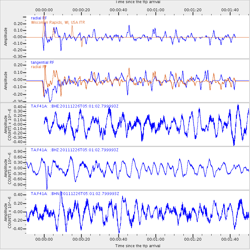
F41A Wisconsin Rapids, WI, USA - Earthquake Result Viewer
*The percent match for this event was below the threshold and hence no stack was calculated.
| Earthquake location: |
Tonga Islands |
| Earthquake latitude/longitude: |
-16.2/-173.9 |
| Earthquake time(UTC): |
2011/12/26 (360) 04:48:08 GMT |
| Earthquake Depth: |
90 km |
| Earthquake Magnitude: |
5.8 MB, 6.0 MW, 6.0 MW |
| Earthquake Catalog/Contributor: |
WHDF/NEIC |
|
| Network: |
TA USArray Transportable Network (new EarthScope stations) |
| Station: |
F41A Wisconsin Rapids, WI, USA |
| Lat/Lon: |
45.74 N/89.10 W |
| Elevation: |
509 m |
|
| Distance: |
97.8 deg |
| Az: |
44.747 deg |
| Baz: |
254.975 deg |
| Ray Param: |
$rayparam |
*The percent match for this event was below the threshold and hence was not used in the summary stack. |
|
| Radial Match: |
63.161705 % |
| Radial Bump: |
400 |
| Transverse Match: |
54.612514 % |
| Transverse Bump: |
400 |
| SOD ConfigId: |
434841 |
| Insert Time: |
2012-03-15 04:53:44.215 +0000 |
| GWidth: |
2.5 |
| Max Bumps: |
400 |
| Tol: |
0.001 |
|
Signal To Noise
| Channel | StoN | STA | LTA |
| TA:F41A: :BHZ:20111226T05:01:02.799993Z | 2.5369248 | 4.456481E-7 | 1.7566468E-7 |
| TA:F41A: :BHN:20111226T05:01:02.799993Z | 0.54808205 | 9.521558E-8 | 1.7372504E-7 |
| TA:F41A: :BHE:20111226T05:01:02.799993Z | 1.184399 | 1.8511632E-7 | 1.5629558E-7 |
| Arrivals |
| Ps | |
| PpPs | |
| PsPs/PpSs | |


