You are here: Home > Network List > G - GEOSCOPE Stations List
> Station HYB Hyderabad, India > Earthquake Result Viewer
HYB Hyderabad, India - Earthquake Result Viewer
| Earthquake location: |
Banda Sea |
| Earthquake latitude/longitude: |
-7.3/128.5 |
| Earthquake time(UTC): |
2000/03/03 (063) 22:09:13 GMT |
| Earthquake Depth: |
142 km |
| Earthquake Magnitude: |
6.4 MB, 5.8 MS, 6.3 MW, 6.3 MW |
| Earthquake Catalog/Contributor: |
WHDF/NEIC |
|
| Network: |
G GEOSCOPE |
| Station: |
HYB Hyderabad, India |
| Lat/Lon: |
17.42 N/78.55 E |
| Elevation: |
510 m |
|
| Distance: |
55.1 deg |
| Az: |
297.036 deg |
| Baz: |
112.263 deg |
| Ray Param: |
0.0645423 |
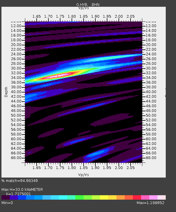
| Estimated Moho Depth: |
33.0 km |
| Estimated Crust Vp/Vs: |
1.74 |
| Assumed Crust Vp: |
6.459 km/s |
| Estimated Crust Vs: |
3.718 km/s |
| Estimated Crust Poisson's Ratio: |
0.25 |
|
| Radial Match: |
94.98349 % |
| Radial Bump: |
306 |
| Transverse Match: |
81.45002 % |
| Transverse Bump: |
400 |
| SOD ConfigId: |
3744 |
| Insert Time: |
2010-02-26 23:00:41.648 +0000 |
| GWidth: |
2.5 |
| Max Bumps: |
400 |
| Tol: |
0.001 |
|
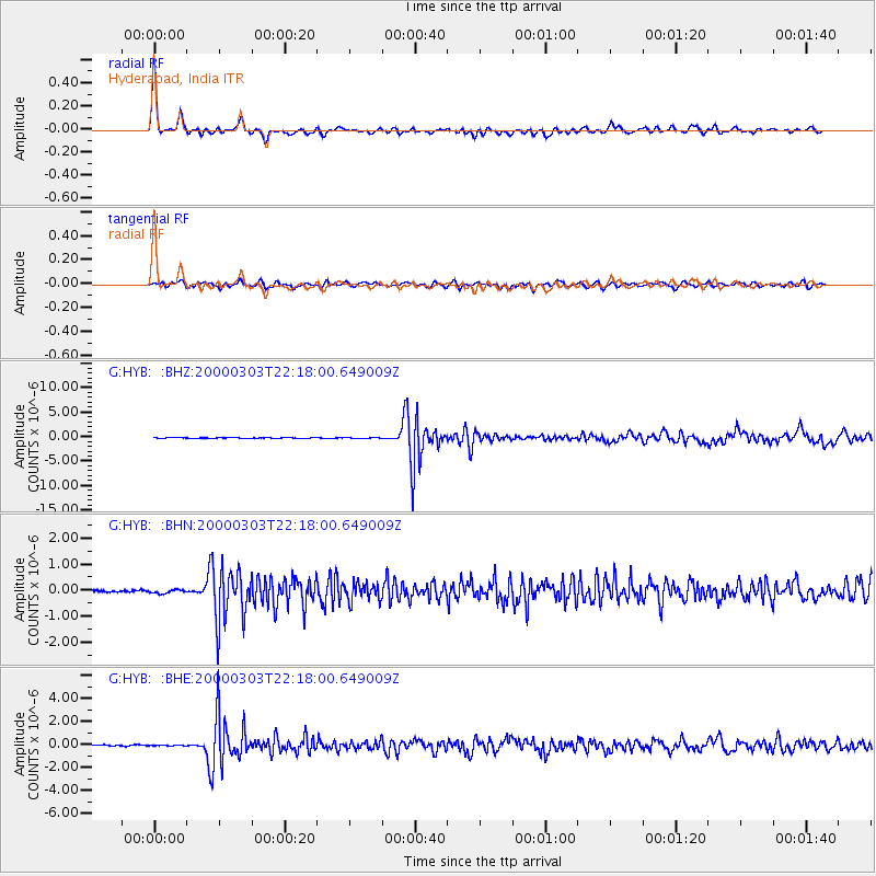
Signal To Noise
| Channel | StoN | STA | LTA |
| G:HYB: :BHN:20000303T22:18:00.649009Z | 1.332264 | 6.908693E-8 | 5.1856787E-8 |
| G:HYB: :BHE:20000303T22:18:00.649009Z | 0.59387946 | 2.5821839E-8 | 4.3479933E-8 |
| G:HYB: :BHZ:20000303T22:18:00.649009Z | 0.92530006 | 6.466675E-8 | 6.988733E-8 |
| Arrivals |
| Ps | 4.0 SECOND |
| PpPs | 13 SECOND |
| PsPs/PpSs | 17 SECOND |


