You are here: Home > Network List > UW - Pacific Northwest Regional Seismic Network Stations List
> Station UMAT Pilot Rock, OR, USA > Earthquake Result Viewer
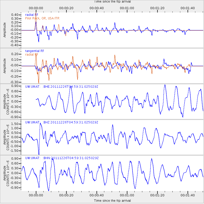
UMAT Pilot Rock, OR, USA - Earthquake Result Viewer
*The percent match for this event was below the threshold and hence no stack was calculated.
| Earthquake location: |
Tonga Islands |
| Earthquake latitude/longitude: |
-16.2/-173.9 |
| Earthquake time(UTC): |
2011/12/26 (360) 04:48:08 GMT |
| Earthquake Depth: |
90 km |
| Earthquake Magnitude: |
5.8 MB, 6.0 MW, 6.0 MW |
| Earthquake Catalog/Contributor: |
WHDF/NEIC |
|
| Network: |
UW Pacific Northwest Regional Seismic Network |
| Station: |
UMAT Pilot Rock, OR, USA |
| Lat/Lon: |
45.29 N/118.96 W |
| Elevation: |
1318 m |
|
| Distance: |
78.8 deg |
| Az: |
36.064 deg |
| Baz: |
233.251 deg |
| Ray Param: |
$rayparam |
*The percent match for this event was below the threshold and hence was not used in the summary stack. |
|
| Radial Match: |
66.88626 % |
| Radial Bump: |
290 |
| Transverse Match: |
36.49814 % |
| Transverse Bump: |
400 |
| SOD ConfigId: |
434841 |
| Insert Time: |
2012-03-15 04:56:15.616 +0000 |
| GWidth: |
2.5 |
| Max Bumps: |
400 |
| Tol: |
0.001 |
|
Signal To Noise
| Channel | StoN | STA | LTA |
| UW:UMAT: :BHZ:20111226T04:59:31.025029Z | 3.4459887 | 9.639842E-7 | 2.7974096E-7 |
| UW:UMAT: :BHN:20111226T04:59:31.025029Z | 2.0793784 | 3.7323397E-7 | 1.7949306E-7 |
| UW:UMAT: :BHE:20111226T04:59:31.025029Z | 0.9546375 | 3.3784823E-7 | 3.539021E-7 |
| Arrivals |
| Ps | |
| PpPs | |
| PsPs/PpSs | |


