You are here: Home > Network List > TA - USArray Transportable Network (new EarthScope stations) Stations List
> Station J34A George, IA, USA > Earthquake Result Viewer
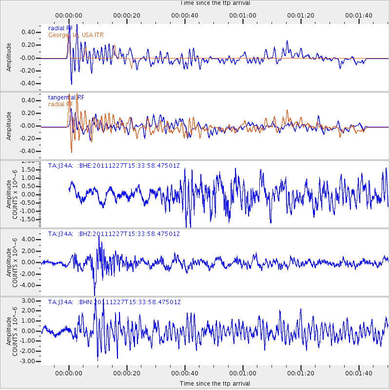
J34A George, IA, USA - Earthquake Result Viewer
*The percent match for this event was below the threshold and hence no stack was calculated.
| Earthquake location: |
Southwestern Siberia, Russia |
| Earthquake latitude/longitude: |
51.8/95.9 |
| Earthquake time(UTC): |
2011/12/27 (361) 15:21:56 GMT |
| Earthquake Depth: |
15 km |
| Earthquake Magnitude: |
6.1 MB, 6.7 MS, 6.6 MW, 6.6 MW |
| Earthquake Catalog/Contributor: |
WHDF/NEIC |
|
| Network: |
TA USArray Transportable Network (new EarthScope stations) |
| Station: |
J34A George, IA, USA |
| Lat/Lon: |
43.28 N/95.96 W |
| Elevation: |
432 m |
|
| Distance: |
84.7 deg |
| Az: |
8.676 deg |
| Baz: |
352.637 deg |
| Ray Param: |
$rayparam |
*The percent match for this event was below the threshold and hence was not used in the summary stack. |
|
| Radial Match: |
59.871765 % |
| Radial Bump: |
400 |
| Transverse Match: |
57.377968 % |
| Transverse Bump: |
400 |
| SOD ConfigId: |
434841 |
| Insert Time: |
2012-03-15 05:23:23.444 +0000 |
| GWidth: |
2.5 |
| Max Bumps: |
400 |
| Tol: |
0.001 |
|
Signal To Noise
| Channel | StoN | STA | LTA |
| TA:J34A: :BHZ:20111227T15:33:58.47501Z | 3.0729444 | 8.294013E-7 | 2.6990443E-7 |
| TA:J34A: :BHN:20111227T15:33:58.47501Z | 2.1880233 | 7.235488E-7 | 3.3068605E-7 |
| TA:J34A: :BHE:20111227T15:33:58.47501Z | 1.2192084 | 3.8339962E-7 | 3.1446604E-7 |
| Arrivals |
| Ps | |
| PpPs | |
| PsPs/PpSs | |


