You are here: Home > Network List > G - GEOSCOPE Stations List
> Station HYB Hyderabad, India > Earthquake Result Viewer
HYB Hyderabad, India - Earthquake Result Viewer
| Earthquake location: |
Santa Cruz Islands |
| Earthquake latitude/longitude: |
-11.3/165.4 |
| Earthquake time(UTC): |
2000/05/06 (127) 13:44:13 GMT |
| Earthquake Depth: |
12 km |
| Earthquake Magnitude: |
6.0 MB, 6.3 MS, 6.3 MW, 5.8 ME |
| Earthquake Catalog/Contributor: |
WHDF/NEIC |
|
| Network: |
G GEOSCOPE |
| Station: |
HYB Hyderabad, India |
| Lat/Lon: |
17.42 N/78.55 E |
| Elevation: |
510 m |
|
| Distance: |
90.4 deg |
| Az: |
287.574 deg |
| Baz: |
101.635 deg |
| Ray Param: |
0.041676067 |
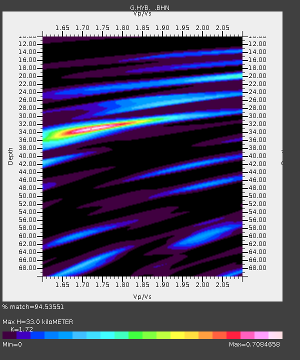
| Estimated Moho Depth: |
33.0 km |
| Estimated Crust Vp/Vs: |
1.72 |
| Assumed Crust Vp: |
6.459 km/s |
| Estimated Crust Vs: |
3.755 km/s |
| Estimated Crust Poisson's Ratio: |
0.24 |
|
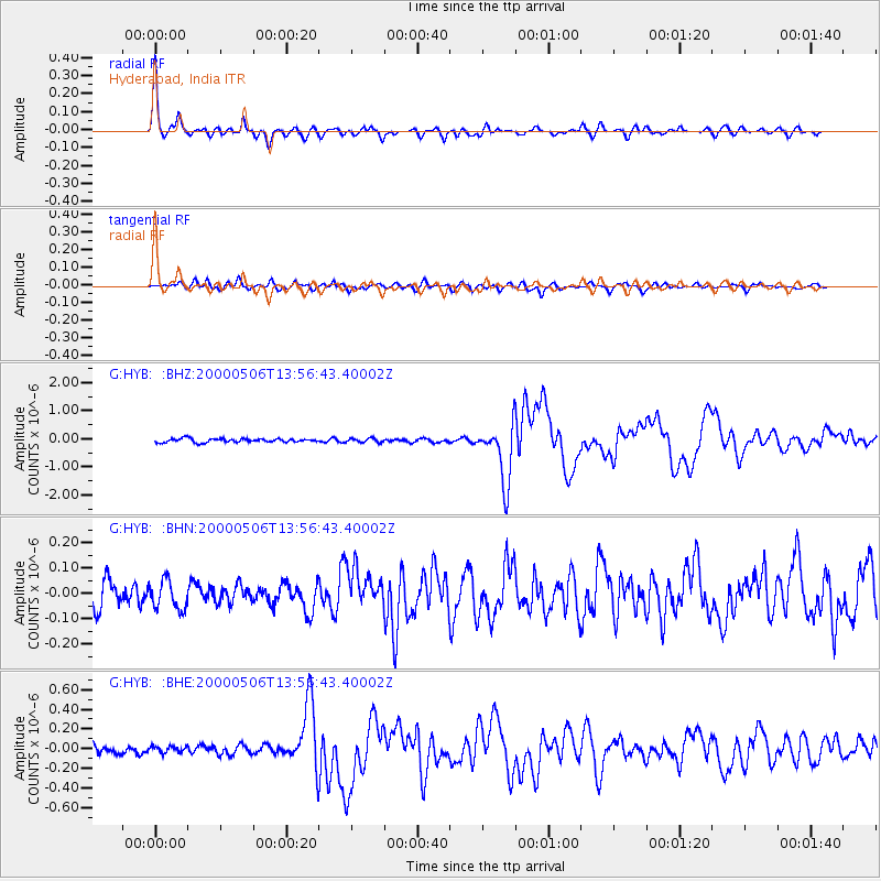
| Radial Match: |
94.53551 % |
| Radial Bump: |
327 |
| Transverse Match: |
74.28958 % |
| Transverse Bump: |
400 |
| SOD ConfigId: |
3744 |
| Insert Time: |
2010-02-26 23:01:04.773 +0000 |
| GWidth: |
2.5 |
| Max Bumps: |
400 |
| Tol: |
0.001 |
|
Signal To Noise
| Channel | StoN | STA | LTA |
| G:HYB: :BHN:20000506T13:56:43.40002Z | 1.1804076 | 5.564217E-8 | 4.71381E-8 |
| G:HYB: :BHE:20000506T13:56:43.40002Z | 0.6671565 | 3.1950524E-8 | 4.7890595E-8 |
| G:HYB: :BHZ:20000506T13:56:43.40002Z | 1.0806453 | 7.3115984E-8 | 6.7659556E-8 |
| Arrivals |
| Ps | 3.8 SECOND |
| PpPs | 14 SECOND |
| PsPs/PpSs | 17 SECOND |


