You are here: Home > Network List > TA - USArray Transportable Network (new EarthScope stations) Stations List
> Station N38A Joe's South Fork Station, Corydon, IA, USA > Earthquake Result Viewer
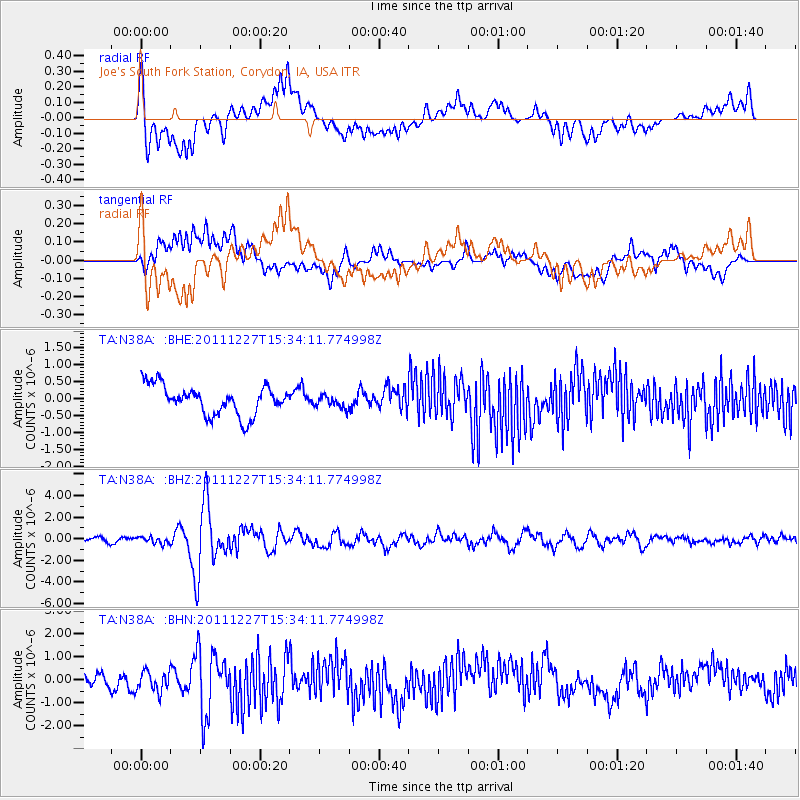
N38A Joe's South Fork Station, Corydon, IA, USA - Earthquake Result Viewer
*The percent match for this event was below the threshold and hence no stack was calculated.
| Earthquake location: |
Southwestern Siberia, Russia |
| Earthquake latitude/longitude: |
51.8/95.9 |
| Earthquake time(UTC): |
2011/12/27 (361) 15:21:56 GMT |
| Earthquake Depth: |
15 km |
| Earthquake Magnitude: |
6.1 MB, 6.7 MS, 6.6 MW, 6.6 MW |
| Earthquake Catalog/Contributor: |
WHDF/NEIC |
|
| Network: |
TA USArray Transportable Network (new EarthScope stations) |
| Station: |
N38A Joe's South Fork Station, Corydon, IA, USA |
| Lat/Lon: |
40.79 N/93.24 W |
| Elevation: |
317 m |
|
| Distance: |
87.4 deg |
| Az: |
6.939 deg |
| Baz: |
354.335 deg |
| Ray Param: |
$rayparam |
*The percent match for this event was below the threshold and hence was not used in the summary stack. |
|
| Radial Match: |
79.03878 % |
| Radial Bump: |
400 |
| Transverse Match: |
62.45169 % |
| Transverse Bump: |
400 |
| SOD ConfigId: |
434841 |
| Insert Time: |
2012-03-15 05:25:19.069 +0000 |
| GWidth: |
2.5 |
| Max Bumps: |
400 |
| Tol: |
0.001 |
|
Signal To Noise
| Channel | StoN | STA | LTA |
| TA:N38A: :BHZ:20111227T15:34:11.774998Z | 1.03002 | 3.1693185E-7 | 3.0769485E-7 |
| TA:N38A: :BHN:20111227T15:34:11.774998Z | 1.4175375 | 4.737198E-7 | 3.3418502E-7 |
| TA:N38A: :BHE:20111227T15:34:11.774998Z | 0.42925447 | 1.8534412E-7 | 4.3178144E-7 |
| Arrivals |
| Ps | |
| PpPs | |
| PsPs/PpSs | |


