You are here: Home > Network List > G - GEOSCOPE Stations List
> Station HYB Hyderabad, India > Earthquake Result Viewer
HYB Hyderabad, India - Earthquake Result Viewer
| Earthquake location: |
Kuril Islands |
| Earthquake latitude/longitude: |
43.0/146.8 |
| Earthquake time(UTC): |
2000/01/28 (028) 14:21:07 GMT |
| Earthquake Depth: |
61 km |
| Earthquake Magnitude: |
6.7 MB, 6.6 MS, 6.8 MW, 6.8 ME |
| Earthquake Catalog/Contributor: |
WHDF/NEIC |
|
| Network: |
G GEOSCOPE |
| Station: |
HYB Hyderabad, India |
| Lat/Lon: |
17.42 N/78.55 E |
| Elevation: |
510 m |
|
| Distance: |
62.5 deg |
| Az: |
268.568 deg |
| Baz: |
50.14 deg |
| Ray Param: |
0.060021453 |
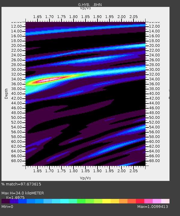
| Estimated Moho Depth: |
34.0 km |
| Estimated Crust Vp/Vs: |
1.70 |
| Assumed Crust Vp: |
6.459 km/s |
| Estimated Crust Vs: |
3.805 km/s |
| Estimated Crust Poisson's Ratio: |
0.23 |
|
| Radial Match: |
97.673615 % |
| Radial Bump: |
304 |
| Transverse Match: |
86.54456 % |
| Transverse Bump: |
400 |
| SOD ConfigId: |
3744 |
| Insert Time: |
2010-02-26 23:01:12.510 +0000 |
| GWidth: |
2.5 |
| Max Bumps: |
400 |
| Tol: |
0.001 |
|
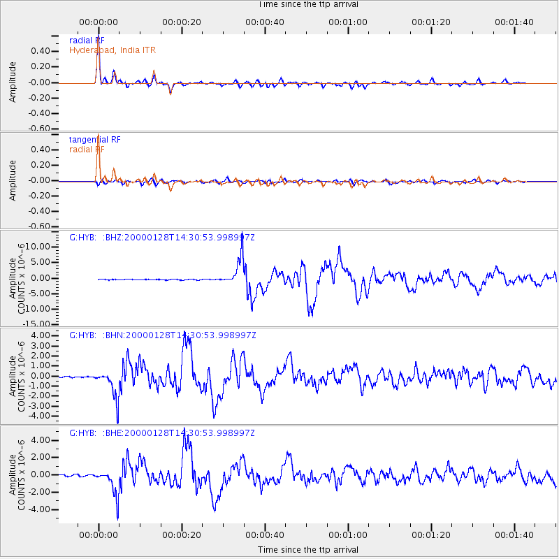
Signal To Noise
| Channel | StoN | STA | LTA |
| G:HYB: :BHN:20000128T14:30:53.998997Z | 34.584484 | 1.4686367E-6 | 4.2465192E-8 |
| G:HYB: :BHE:20000128T14:30:53.998997Z | 21.274612 | 1.5788493E-6 | 7.4212835E-8 |
| G:HYB: :BHZ:20000128T14:30:53.998997Z | 43.221077 | 4.7787003E-6 | 1.10564116E-7 |
| Arrivals |
| Ps | 3.8 SECOND |
| PpPs | 14 SECOND |
| PsPs/PpSs | 17 SECOND |


