You are here: Home > Network List > UW - Pacific Northwest Regional Seismic Network Stations List
> Station UMAT Pilot Rock, OR, USA > Earthquake Result Viewer
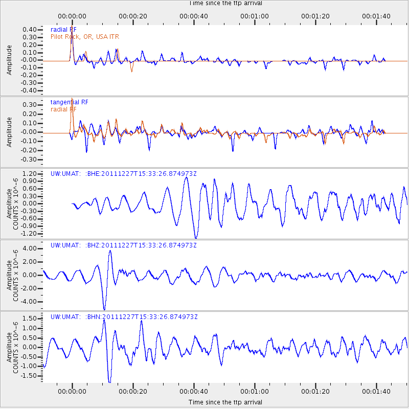
UMAT Pilot Rock, OR, USA - Earthquake Result Viewer
*The percent match for this event was below the threshold and hence no stack was calculated.
| Earthquake location: |
Southwestern Siberia, Russia |
| Earthquake latitude/longitude: |
51.8/95.9 |
| Earthquake time(UTC): |
2011/12/27 (361) 15:21:56 GMT |
| Earthquake Depth: |
15 km |
| Earthquake Magnitude: |
6.1 MB, 6.7 MS, 6.6 MW, 6.6 MW |
| Earthquake Catalog/Contributor: |
WHDF/NEIC |
|
| Network: |
UW Pacific Northwest Regional Seismic Network |
| Station: |
UMAT Pilot Rock, OR, USA |
| Lat/Lon: |
45.29 N/118.96 W |
| Elevation: |
1318 m |
|
| Distance: |
78.7 deg |
| Az: |
24.304 deg |
| Baz: |
338.794 deg |
| Ray Param: |
$rayparam |
*The percent match for this event was below the threshold and hence was not used in the summary stack. |
|
| Radial Match: |
69.734924 % |
| Radial Bump: |
308 |
| Transverse Match: |
61.73099 % |
| Transverse Bump: |
311 |
| SOD ConfigId: |
434841 |
| Insert Time: |
2012-03-15 05:29:59.943 +0000 |
| GWidth: |
2.5 |
| Max Bumps: |
400 |
| Tol: |
0.001 |
|
Signal To Noise
| Channel | StoN | STA | LTA |
| UW:UMAT: :BHZ:20111227T15:33:26.874973Z | 1.5725195 | 6.758608E-7 | 4.2979482E-7 |
| UW:UMAT: :BHN:20111227T15:33:26.874973Z | 0.8159596 | 3.216872E-7 | 3.94244E-7 |
| UW:UMAT: :BHE:20111227T15:33:26.874973Z | 2.5096653 | 4.997126E-7 | 1.9911526E-7 |
| Arrivals |
| Ps | |
| PpPs | |
| PsPs/PpSs | |


