You are here: Home > Network List > CI - Caltech Regional Seismic Network Stations List
> Station RCT Rector, Visalia, CA, USA > Earthquake Result Viewer
RCT Rector, Visalia, CA, USA - Earthquake Result Viewer
| Earthquake location: |
Southeast Of Honshu, Japan |
| Earthquake latitude/longitude: |
31.5/138.1 |
| Earthquake time(UTC): |
2012/01/01 (001) 05:27:55 GMT |
| Earthquake Depth: |
365 km |
| Earthquake Magnitude: |
6.2 MB, 6.8 MW, 6.8 MW |
| Earthquake Catalog/Contributor: |
WHDF/NEIC |
|
| Network: |
CI Caltech Regional Seismic Network |
| Station: |
RCT Rector, Visalia, CA, USA |
| Lat/Lon: |
36.31 N/119.24 W |
| Elevation: |
107 m |
|
| Distance: |
81.1 deg |
| Az: |
52.905 deg |
| Baz: |
302.448 deg |
| Ray Param: |
0.046822183 |
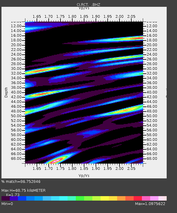
| Estimated Moho Depth: |
68.75 km |
| Estimated Crust Vp/Vs: |
1.73 |
| Assumed Crust Vp: |
6.291 km/s |
| Estimated Crust Vs: |
3.637 km/s |
| Estimated Crust Poisson's Ratio: |
0.25 |
|
| Radial Match: |
86.752846 % |
| Radial Bump: |
400 |
| Transverse Match: |
70.98212 % |
| Transverse Bump: |
400 |
| SOD ConfigId: |
434841 |
| Insert Time: |
2012-03-18 07:50:26.329 +0000 |
| GWidth: |
2.5 |
| Max Bumps: |
400 |
| Tol: |
0.001 |
|
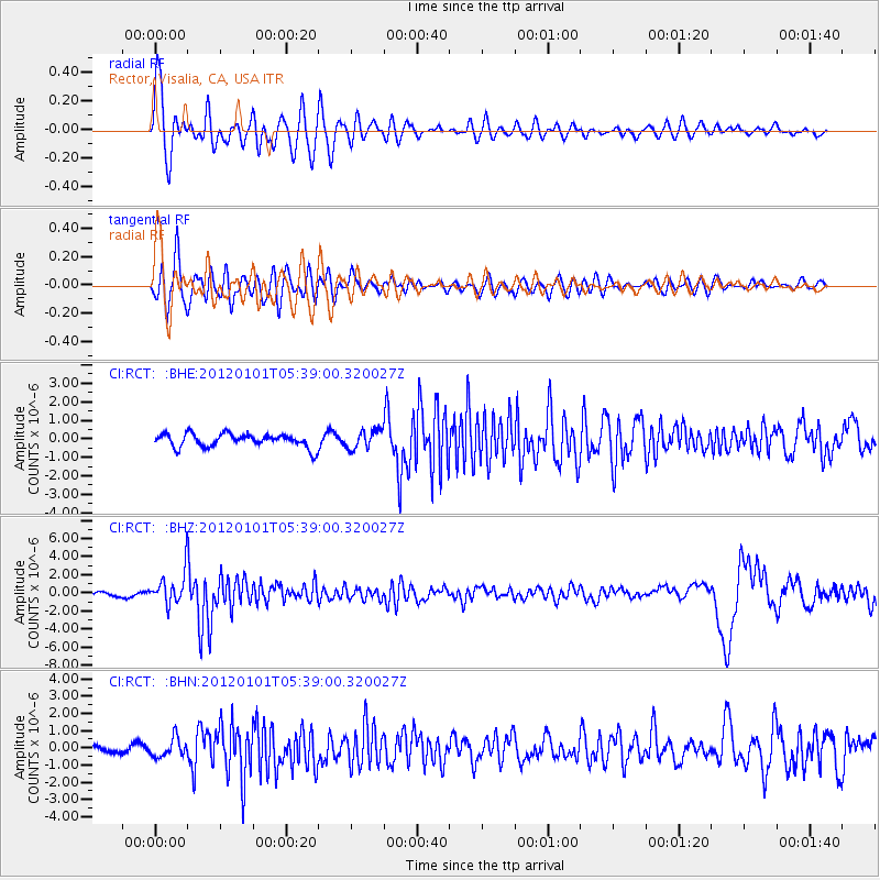
Signal To Noise
| Channel | StoN | STA | LTA |
| CI:RCT: :BHZ:20120101T05:39:00.320027Z | 8.502841 | 1.7550414E-6 | 2.0640647E-7 |
| CI:RCT: :BHN:20120101T05:39:00.320027Z | 2.7555852 | 5.321353E-7 | 1.9311155E-7 |
| CI:RCT: :BHE:20120101T05:39:00.320027Z | 1.3996009 | 5.1253375E-7 | 3.6619997E-7 |
| Arrivals |
| Ps | 8.2 SECOND |
| PpPs | 29 SECOND |
| PsPs/PpSs | 37 SECOND |


