You are here: Home > Network List > CI - Caltech Regional Seismic Network Stations List
> Station FMP Fort MacArthur Park, Pt. Fermin San Pedro, CA, USA > Earthquake Result Viewer
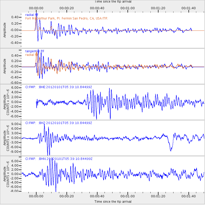
FMP Fort MacArthur Park, Pt. Fermin San Pedro, CA, USA - Earthquake Result Viewer
| Earthquake location: |
Southeast Of Honshu, Japan |
| Earthquake latitude/longitude: |
31.5/138.1 |
| Earthquake time(UTC): |
2012/01/01 (001) 05:27:55 GMT |
| Earthquake Depth: |
365 km |
| Earthquake Magnitude: |
6.2 MB, 6.8 MW, 6.8 MW |
| Earthquake Catalog/Contributor: |
WHDF/NEIC |
|
| Network: |
CI Caltech Regional Seismic Network |
| Station: |
FMP Fort MacArthur Park, Pt. Fermin San Pedro, CA, USA |
| Lat/Lon: |
33.71 N/118.29 W |
| Elevation: |
89 m |
|
| Distance: |
83.2 deg |
| Az: |
54.672 deg |
| Baz: |
303.232 deg |
| Ray Param: |
0.045410313 |
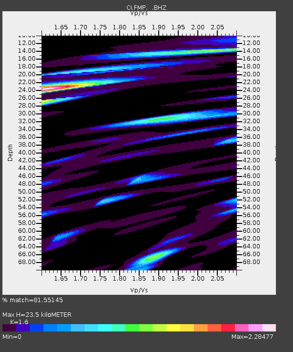
| Estimated Moho Depth: |
23.5 km |
| Estimated Crust Vp/Vs: |
1.60 |
| Assumed Crust Vp: |
6.048 km/s |
| Estimated Crust Vs: |
3.78 km/s |
| Estimated Crust Poisson's Ratio: |
0.18 |
|
| Radial Match: |
81.55145 % |
| Radial Bump: |
400 |
| Transverse Match: |
78.83279 % |
| Transverse Bump: |
400 |
| SOD ConfigId: |
434841 |
| Insert Time: |
2012-03-18 07:51:13.518 +0000 |
| GWidth: |
2.5 |
| Max Bumps: |
400 |
| Tol: |
0.001 |
|
Signal To Noise
| Channel | StoN | STA | LTA |
| CI:FMP: :BHZ:20120101T05:39:10.84499Z | 4.243961 | 1.529522E-6 | 3.6039967E-7 |
| CI:FMP: :BHN:20120101T05:39:10.84499Z | 1.7727749 | 1.1419367E-6 | 6.4415207E-7 |
| CI:FMP: :BHE:20120101T05:39:10.84499Z | 2.197483 | 1.2528716E-6 | 5.701394E-7 |
| Arrivals |
| Ps | 2.4 SECOND |
| PpPs | 9.9 SECOND |
| PsPs/PpSs | 12 SECOND |


