You are here: Home > Network List > IW - Intermountain West Stations List
> Station MOOW Moose Ponds, Wyoming, USA > Earthquake Result Viewer
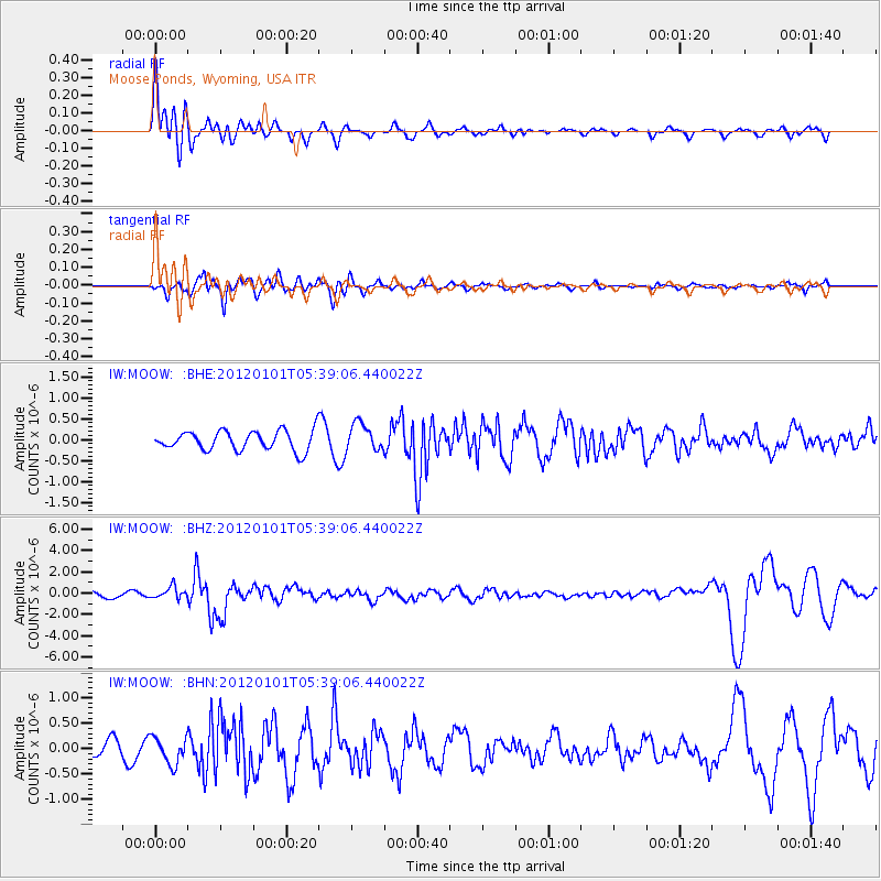
MOOW Moose Ponds, Wyoming, USA - Earthquake Result Viewer
*The percent match for this event was below the threshold and hence no stack was calculated.
| Earthquake location: |
Southeast Of Honshu, Japan |
| Earthquake latitude/longitude: |
31.5/138.1 |
| Earthquake time(UTC): |
2012/01/01 (001) 05:27:55 GMT |
| Earthquake Depth: |
365 km |
| Earthquake Magnitude: |
6.2 MB, 6.8 MW, 6.8 MW |
| Earthquake Catalog/Contributor: |
WHDF/NEIC |
|
| Network: |
IW Intermountain West |
| Station: |
MOOW Moose Ponds, Wyoming, USA |
| Lat/Lon: |
43.75 N/110.74 W |
| Elevation: |
2128 m |
|
| Distance: |
82.3 deg |
| Az: |
42.991 deg |
| Baz: |
306.476 deg |
| Ray Param: |
$rayparam |
*The percent match for this event was below the threshold and hence was not used in the summary stack. |
|
| Radial Match: |
78.81508 % |
| Radial Bump: |
400 |
| Transverse Match: |
72.09815 % |
| Transverse Bump: |
400 |
| SOD ConfigId: |
434841 |
| Insert Time: |
2012-03-18 07:57:54.595 +0000 |
| GWidth: |
2.5 |
| Max Bumps: |
400 |
| Tol: |
0.001 |
|
Signal To Noise
| Channel | StoN | STA | LTA |
| IW:MOOW: :BHZ:20120101T05:39:06.440022Z | 2.206722 | 5.5123894E-7 | 2.4979988E-7 |
| IW:MOOW: :BHN:20120101T05:39:06.440022Z | 2.189355 | 2.6133986E-7 | 1.1936842E-7 |
| IW:MOOW: :BHE:20120101T05:39:06.440022Z | 1.4013904 | 3.2567215E-7 | 2.3239217E-7 |
| Arrivals |
| Ps | |
| PpPs | |
| PsPs/PpSs | |


