You are here: Home > Network List > PL - Polish Seismological Network Stations List
> Station GKP GORKA KLASZTORNA, POLAND > Earthquake Result Viewer
GKP GORKA KLASZTORNA, POLAND - Earthquake Result Viewer
| Earthquake location: |
Southeast Of Honshu, Japan |
| Earthquake latitude/longitude: |
31.5/138.1 |
| Earthquake time(UTC): |
2012/01/01 (001) 05:27:55 GMT |
| Earthquake Depth: |
365 km |
| Earthquake Magnitude: |
6.2 MB, 6.8 MW, 6.8 MW |
| Earthquake Catalog/Contributor: |
WHDF/NEIC |
|
| Network: |
PL Polish Seismological Network |
| Station: |
GKP GORKA KLASZTORNA, POLAND |
| Lat/Lon: |
53.27 N/17.24 E |
| Elevation: |
115 m |
|
| Distance: |
81.3 deg |
| Az: |
328.547 deg |
| Baz: |
47.939 deg |
| Ray Param: |
0.04672548 |
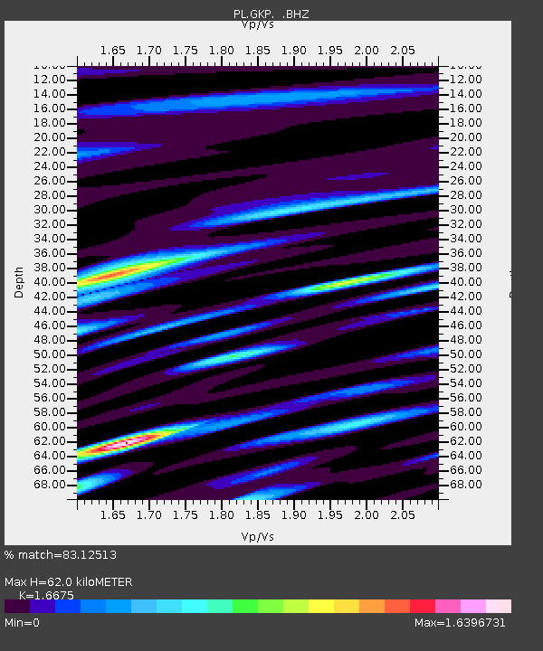
| Estimated Moho Depth: |
62.0 km |
| Estimated Crust Vp/Vs: |
1.67 |
| Assumed Crust Vp: |
6.234 km/s |
| Estimated Crust Vs: |
3.738 km/s |
| Estimated Crust Poisson's Ratio: |
0.22 |
|
| Radial Match: |
83.12513 % |
| Radial Bump: |
400 |
| Transverse Match: |
78.96901 % |
| Transverse Bump: |
400 |
| SOD ConfigId: |
434841 |
| Insert Time: |
2012-03-18 08:03:14.017 +0000 |
| GWidth: |
2.5 |
| Max Bumps: |
400 |
| Tol: |
0.001 |
|

Signal To Noise
| Channel | StoN | STA | LTA |
| PL:GKP: :BHZ:20120101T05:39:01.065022Z | 7.3769126 | 2.2760485E-6 | 3.0853673E-7 |
| PL:GKP: :BHN:20120101T05:39:01.045002Z | 1.3028088 | 8.4958236E-7 | 6.5211594E-7 |
| PL:GKP: :BHE:20120101T05:39:01.08498Z | 0.7741128 | 5.592212E-7 | 7.2240266E-7 |
| Arrivals |
| Ps | 6.8 SECOND |
| PpPs | 26 SECOND |
| PsPs/PpSs | 33 SECOND |


