You are here: Home > Network List > TA - USArray Transportable Network (new EarthScope stations) Stations List
> Station E31A Nome, ND, USA > Earthquake Result Viewer
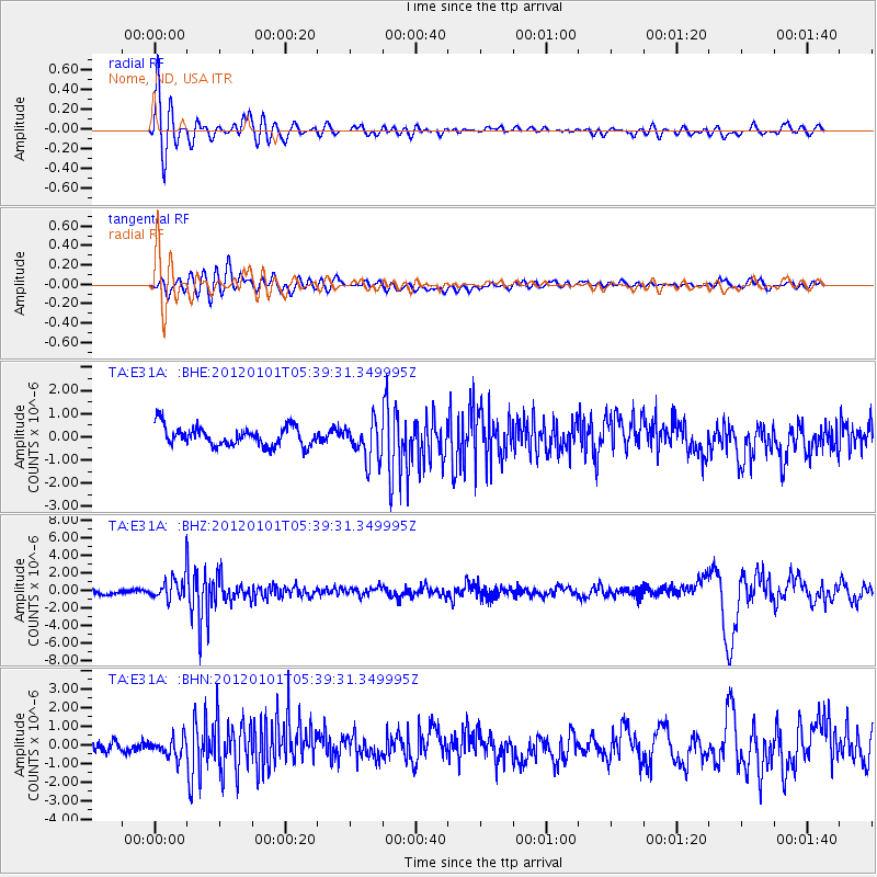
E31A Nome, ND, USA - Earthquake Result Viewer
*The percent match for this event was below the threshold and hence no stack was calculated.
| Earthquake location: |
Southeast Of Honshu, Japan |
| Earthquake latitude/longitude: |
31.5/138.1 |
| Earthquake time(UTC): |
2012/01/01 (001) 05:27:55 GMT |
| Earthquake Depth: |
365 km |
| Earthquake Magnitude: |
6.2 MB, 6.8 MW, 6.8 MW |
| Earthquake Catalog/Contributor: |
WHDF/NEIC |
|
| Network: |
TA USArray Transportable Network (new EarthScope stations) |
| Station: |
E31A Nome, ND, USA |
| Lat/Lon: |
46.56 N/97.89 W |
| Elevation: |
427 m |
|
| Distance: |
87.4 deg |
| Az: |
34.918 deg |
| Baz: |
314.855 deg |
| Ray Param: |
$rayparam |
*The percent match for this event was below the threshold and hence was not used in the summary stack. |
|
| Radial Match: |
73.303635 % |
| Radial Bump: |
400 |
| Transverse Match: |
52.23546 % |
| Transverse Bump: |
400 |
| SOD ConfigId: |
434841 |
| Insert Time: |
2012-03-18 08:09:29.063 +0000 |
| GWidth: |
2.5 |
| Max Bumps: |
400 |
| Tol: |
0.001 |
|
Signal To Noise
| Channel | StoN | STA | LTA |
| TA:E31A: :BHZ:20120101T05:39:31.349995Z | 4.728688 | 1.3726868E-6 | 2.9028917E-7 |
| TA:E31A: :BHN:20120101T05:39:31.349995Z | 1.0503834 | 5.0774565E-7 | 4.8339075E-7 |
| TA:E31A: :BHE:20120101T05:39:31.349995Z | 1.9807551 | 8.2192446E-7 | 4.149551E-7 |
| Arrivals |
| Ps | |
| PpPs | |
| PsPs/PpSs | |


