You are here: Home > Network List > TA - USArray Transportable Network (new EarthScope stations) Stations List
> Station K31A O'Neill, NE, USA > Earthquake Result Viewer
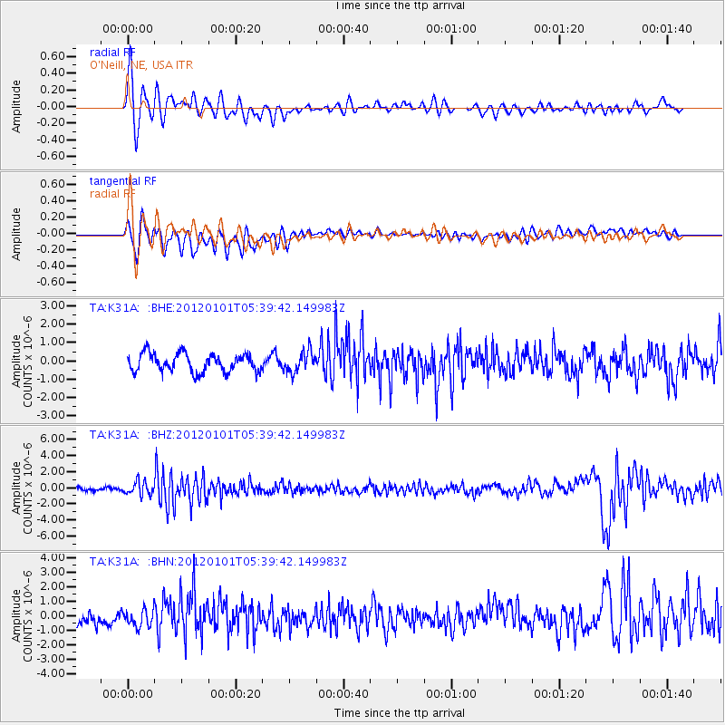
K31A O'Neill, NE, USA - Earthquake Result Viewer
*The percent match for this event was below the threshold and hence no stack was calculated.
| Earthquake location: |
Southeast Of Honshu, Japan |
| Earthquake latitude/longitude: |
31.5/138.1 |
| Earthquake time(UTC): |
2012/01/01 (001) 05:27:55 GMT |
| Earthquake Depth: |
365 km |
| Earthquake Magnitude: |
6.2 MB, 6.8 MW, 6.8 MW |
| Earthquake Catalog/Contributor: |
WHDF/NEIC |
|
| Network: |
TA USArray Transportable Network (new EarthScope stations) |
| Station: |
K31A O'Neill, NE, USA |
| Lat/Lon: |
42.62 N/98.75 W |
| Elevation: |
580 m |
|
| Distance: |
89.7 deg |
| Az: |
38.156 deg |
| Baz: |
314.33 deg |
| Ray Param: |
$rayparam |
*The percent match for this event was below the threshold and hence was not used in the summary stack. |
|
| Radial Match: |
73.84164 % |
| Radial Bump: |
400 |
| Transverse Match: |
63.867855 % |
| Transverse Bump: |
400 |
| SOD ConfigId: |
434841 |
| Insert Time: |
2012-03-18 08:09:44.384 +0000 |
| GWidth: |
2.5 |
| Max Bumps: |
400 |
| Tol: |
0.001 |
|
Signal To Noise
| Channel | StoN | STA | LTA |
| TA:K31A: :BHZ:20120101T05:39:42.149983Z | 3.2329612 | 8.1364226E-7 | 2.516709E-7 |
| TA:K31A: :BHN:20120101T05:39:42.149983Z | 1.4969053 | 5.956686E-7 | 3.9793338E-7 |
| TA:K31A: :BHE:20120101T05:39:42.149983Z | 1.1763802 | 5.830441E-7 | 4.9562556E-7 |
| Arrivals |
| Ps | |
| PpPs | |
| PsPs/PpSs | |


