You are here: Home > Network List > TA - USArray Transportable Network (new EarthScope stations) Stations List
> Station H31A Wolsey, SD, USA > Earthquake Result Viewer
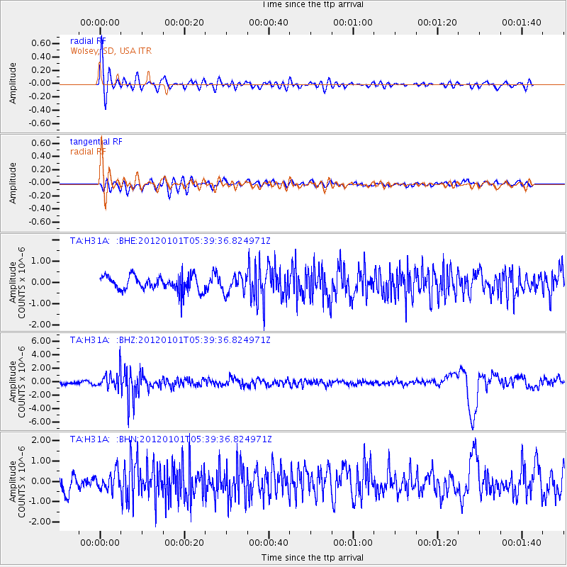
H31A Wolsey, SD, USA - Earthquake Result Viewer
*The percent match for this event was below the threshold and hence no stack was calculated.
| Earthquake location: |
Southeast Of Honshu, Japan |
| Earthquake latitude/longitude: |
31.5/138.1 |
| Earthquake time(UTC): |
2012/01/01 (001) 05:27:55 GMT |
| Earthquake Depth: |
365 km |
| Earthquake Magnitude: |
6.2 MB, 6.8 MW, 6.8 MW |
| Earthquake Catalog/Contributor: |
WHDF/NEIC |
|
| Network: |
TA USArray Transportable Network (new EarthScope stations) |
| Station: |
H31A Wolsey, SD, USA |
| Lat/Lon: |
44.48 N/98.48 W |
| Elevation: |
415 m |
|
| Distance: |
88.5 deg |
| Az: |
36.689 deg |
| Baz: |
314.498 deg |
| Ray Param: |
$rayparam |
*The percent match for this event was below the threshold and hence was not used in the summary stack. |
|
| Radial Match: |
68.58291 % |
| Radial Bump: |
400 |
| Transverse Match: |
47.681583 % |
| Transverse Bump: |
400 |
| SOD ConfigId: |
434841 |
| Insert Time: |
2012-03-18 08:10:00.658 +0000 |
| GWidth: |
2.5 |
| Max Bumps: |
400 |
| Tol: |
0.001 |
|
Signal To Noise
| Channel | StoN | STA | LTA |
| TA:H31A: :BHZ:20120101T05:39:36.824971Z | 5.4439783 | 1.335675E-6 | 2.4534907E-7 |
| TA:H31A: :BHN:20120101T05:39:36.824971Z | 1.0417979 | 4.4265556E-7 | 4.2489586E-7 |
| TA:H31A: :BHE:20120101T05:39:36.824971Z | 1.1896181 | 4.135471E-7 | 3.4763013E-7 |
| Arrivals |
| Ps | |
| PpPs | |
| PsPs/PpSs | |


