You are here: Home > Network List > TA - USArray Transportable Network (new EarthScope stations) Stations List
> Station G31A Conde, SD, USA > Earthquake Result Viewer
G31A Conde, SD, USA - Earthquake Result Viewer
| Earthquake location: |
Southeast Of Honshu, Japan |
| Earthquake latitude/longitude: |
31.5/138.1 |
| Earthquake time(UTC): |
2012/01/01 (001) 05:27:55 GMT |
| Earthquake Depth: |
365 km |
| Earthquake Magnitude: |
6.2 MB, 6.8 MW, 6.8 MW |
| Earthquake Catalog/Contributor: |
WHDF/NEIC |
|
| Network: |
TA USArray Transportable Network (new EarthScope stations) |
| Station: |
G31A Conde, SD, USA |
| Lat/Lon: |
45.23 N/98.21 W |
| Elevation: |
393 m |
|
| Distance: |
88.2 deg |
| Az: |
36.023 deg |
| Baz: |
314.668 deg |
| Ray Param: |
0.041872952 |
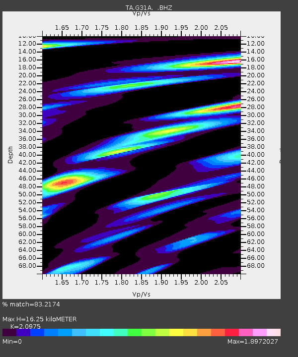
| Estimated Moho Depth: |
16.25 km |
| Estimated Crust Vp/Vs: |
2.10 |
| Assumed Crust Vp: |
6.53 km/s |
| Estimated Crust Vs: |
3.113 km/s |
| Estimated Crust Poisson's Ratio: |
0.35 |
|
| Radial Match: |
83.2174 % |
| Radial Bump: |
400 |
| Transverse Match: |
51.781986 % |
| Transverse Bump: |
400 |
| SOD ConfigId: |
434841 |
| Insert Time: |
2012-03-18 08:11:47.599 +0000 |
| GWidth: |
2.5 |
| Max Bumps: |
400 |
| Tol: |
0.001 |
|

Signal To Noise
| Channel | StoN | STA | LTA |
| TA:G31A: :BHZ:20120101T05:39:35.024983Z | 5.7854757 | 1.3268701E-6 | 2.2934505E-7 |
| TA:G31A: :BHN:20120101T05:39:35.024983Z | 2.2442904 | 9.577359E-7 | 4.2674333E-7 |
| TA:G31A: :BHE:20120101T05:39:35.024983Z | 2.6273394 | 7.6678714E-7 | 2.918493E-7 |
| Arrivals |
| Ps | 2.8 SECOND |
| PpPs | 7.6 SECOND |
| PsPs/PpSs | 10 SECOND |


