You are here: Home > Network List > G - GEOSCOPE Stations List
> Station FDF Fort de France, Martinique France > Earthquake Result Viewer
FDF Fort de France, Martinique France - Earthquake Result Viewer
| Earthquake location: |
South Shetland Islands |
| Earthquake latitude/longitude: |
-61.0/-56.1 |
| Earthquake time(UTC): |
2012/01/15 (015) 13:40:16 GMT |
| Earthquake Depth: |
10 km |
| Earthquake Magnitude: |
5.9 MB |
| Earthquake Catalog/Contributor: |
WHDF/NEIC |
|
| Network: |
G GEOSCOPE |
| Station: |
FDF Fort de France, Martinique France |
| Lat/Lon: |
14.73 N/61.14 W |
| Elevation: |
467 m |
|
| Distance: |
75.6 deg |
| Az: |
354.934 deg |
| Baz: |
177.449 deg |
| Ray Param: |
0.051585793 |
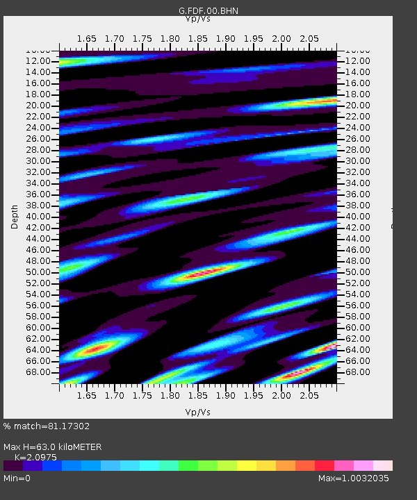
| Estimated Moho Depth: |
63.0 km |
| Estimated Crust Vp/Vs: |
2.10 |
| Assumed Crust Vp: |
5.88 km/s |
| Estimated Crust Vs: |
2.804 km/s |
| Estimated Crust Poisson's Ratio: |
0.35 |
|
| Radial Match: |
81.17302 % |
| Radial Bump: |
400 |
| Transverse Match: |
85.36488 % |
| Transverse Bump: |
400 |
| SOD ConfigId: |
436445 |
| Insert Time: |
2012-04-05 14:39:59.511 +0000 |
| GWidth: |
2.5 |
| Max Bumps: |
400 |
| Tol: |
0.001 |
|
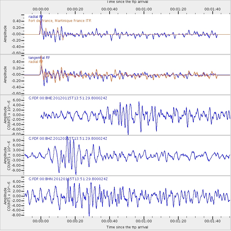
Signal To Noise
| Channel | StoN | STA | LTA |
| G:FDF:00:BHZ:20120115T13:51:29.800024Z | 2.678781 | 1.7732954E-6 | 6.619785E-7 |
| G:FDF:00:BHN:20120115T13:51:29.800024Z | 1.5404352 | 1.944377E-6 | 1.2622257E-6 |
| G:FDF:00:BHE:20120115T13:51:29.800024Z | 1.2084917 | 1.167302E-6 | 9.659165E-7 |
| Arrivals |
| Ps | 12 SECOND |
| PpPs | 32 SECOND |
| PsPs/PpSs | 44 SECOND |


