You are here: Home > Network List > GT - Global Telemetered Seismograph Network (USAF/USGS) Stations List
> Station LPAZ La Paz , Bolivia > Earthquake Result Viewer
LPAZ La Paz , Bolivia - Earthquake Result Viewer
| Earthquake location: |
South Shetland Islands |
| Earthquake latitude/longitude: |
-61.0/-56.1 |
| Earthquake time(UTC): |
2012/01/15 (015) 13:40:16 GMT |
| Earthquake Depth: |
10 km |
| Earthquake Magnitude: |
5.9 MB |
| Earthquake Catalog/Contributor: |
WHDF/NEIC |
|
| Network: |
GT Global Telemetered Seismograph Network (USAF/USGS) |
| Station: |
LPAZ La Paz , Bolivia |
| Lat/Lon: |
16.17 S/68.08 W |
| Elevation: |
4817 m |
|
| Distance: |
45.6 deg |
| Az: |
343.745 deg |
| Baz: |
171.833 deg |
| Ray Param: |
0.07119114 |
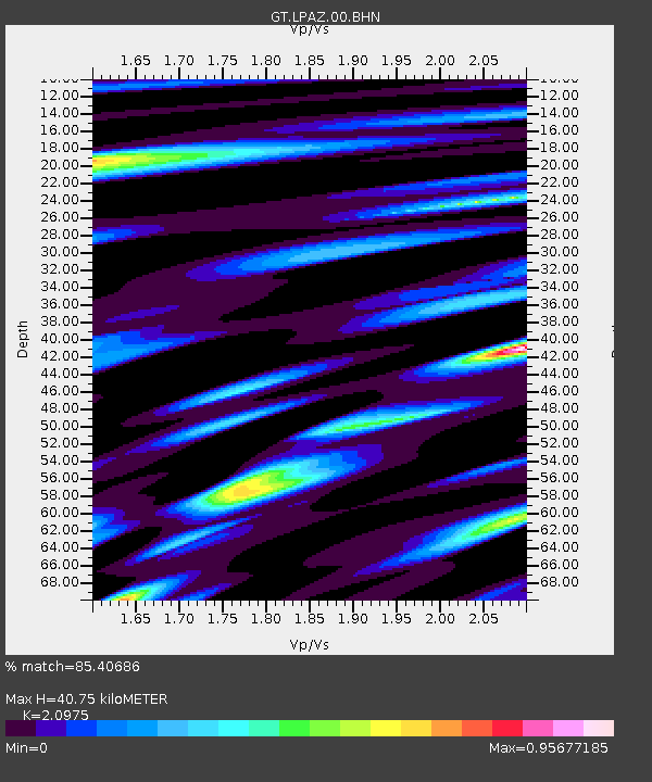
| Estimated Moho Depth: |
40.75 km |
| Estimated Crust Vp/Vs: |
2.10 |
| Assumed Crust Vp: |
6.454 km/s |
| Estimated Crust Vs: |
3.077 km/s |
| Estimated Crust Poisson's Ratio: |
0.35 |
|
| Radial Match: |
85.40686 % |
| Radial Bump: |
400 |
| Transverse Match: |
65.62662 % |
| Transverse Bump: |
400 |
| SOD ConfigId: |
436445 |
| Insert Time: |
2012-04-05 14:40:30.250 +0000 |
| GWidth: |
2.5 |
| Max Bumps: |
400 |
| Tol: |
0.001 |
|
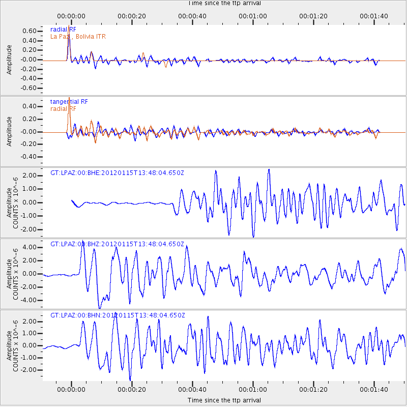
Signal To Noise
| Channel | StoN | STA | LTA |
| GT:LPAZ:00:BHZ:20120115T13:48:04.650Z | 23.515394 | 2.0708273E-6 | 8.806262E-8 |
| GT:LPAZ:00:BHN:20120115T13:48:04.650Z | 8.953904 | 8.510459E-7 | 9.504747E-8 |
| GT:LPAZ:00:BHE:20120115T13:48:04.650Z | 4.45901 | 3.7391624E-7 | 8.385633E-8 |
| Arrivals |
| Ps | 7.3 SECOND |
| PpPs | 19 SECOND |
| PsPs/PpSs | 26 SECOND |


