You are here: Home > Network List > G - GEOSCOPE Stations List
> Station INU Inuyama, Japan > Earthquake Result Viewer
INU Inuyama, Japan - Earthquake Result Viewer
*The percent match for this event was below the threshold and hence no stack was calculated.
| Earthquake location: |
Off W. Coast Of S. Island, N.Z. |
| Earthquake latitude/longitude: |
-46.7/165.8 |
| Earthquake time(UTC): |
2012/01/19 (019) 06:48:48 GMT |
| Earthquake Depth: |
20 km |
| Earthquake Magnitude: |
6.0 MB, 5.8 MS, 5.9 MW, 5.9 MW |
| Earthquake Catalog/Contributor: |
WHDF/NEIC |
|
| Network: |
G GEOSCOPE |
| Station: |
INU Inuyama, Japan |
| Lat/Lon: |
35.35 N/137.03 E |
| Elevation: |
132 m |
|
| Distance: |
85.7 deg |
| Az: |
336.777 deg |
| Baz: |
160.606 deg |
| Ray Param: |
$rayparam |
*The percent match for this event was below the threshold and hence was not used in the summary stack. |
|
| Radial Match: |
63.722023 % |
| Radial Bump: |
325 |
| Transverse Match: |
56.139126 % |
| Transverse Bump: |
400 |
| SOD ConfigId: |
436445 |
| Insert Time: |
2012-04-05 15:09:47.022 +0000 |
| GWidth: |
2.5 |
| Max Bumps: |
400 |
| Tol: |
0.001 |
|
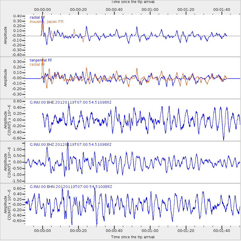
Signal To Noise
| Channel | StoN | STA | LTA |
| G:INU:00:BHZ:20120119T07:00:54.510986Z | 2.087747 | 4.8972674E-7 | 2.3457187E-7 |
| G:INU:00:BHN:20120119T07:00:54.510986Z | 1.2575969 | 2.0147345E-7 | 1.6020513E-7 |
| G:INU:00:BHE:20120119T07:00:54.510986Z | 0.41277254 | 7.130058E-8 | 1.7273578E-7 |
| Arrivals |
| Ps | |
| PpPs | |
| PsPs/PpSs | |


