You are here: Home > Network List > CI - Caltech Regional Seismic Network Stations List
> Station TIN Tinemaha, Big Pine, CA, USA > Earthquake Result Viewer
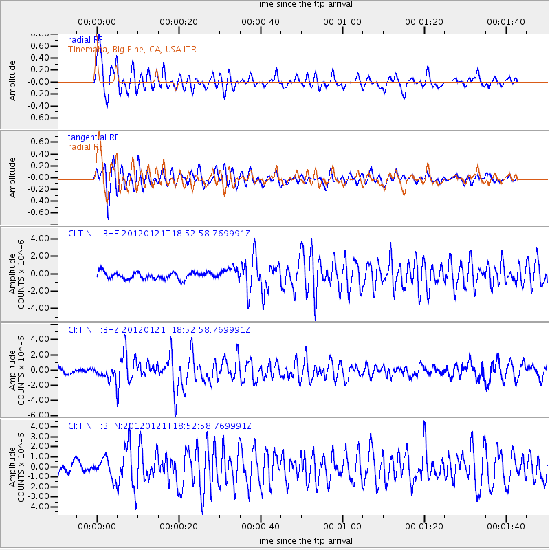
TIN Tinemaha, Big Pine, CA, USA - Earthquake Result Viewer
*The percent match for this event was below the threshold and hence no stack was calculated.
| Earthquake location: |
Near Coast Of Chiapas, Mexico |
| Earthquake latitude/longitude: |
14.9/-93.0 |
| Earthquake time(UTC): |
2012/01/21 (021) 18:47:11 GMT |
| Earthquake Depth: |
45 km |
| Earthquake Magnitude: |
5.9 MB, 5.8 MS, 6.2 MW, 6.3 MW |
| Earthquake Catalog/Contributor: |
WHDF/NEIC |
|
| Network: |
CI Caltech Regional Seismic Network |
| Station: |
TIN Tinemaha, Big Pine, CA, USA |
| Lat/Lon: |
37.05 N/118.23 W |
| Elevation: |
1197 m |
|
| Distance: |
31.5 deg |
| Az: |
319.24 deg |
| Baz: |
127.897 deg |
| Ray Param: |
$rayparam |
*The percent match for this event was below the threshold and hence was not used in the summary stack. |
|
| Radial Match: |
78.793495 % |
| Radial Bump: |
400 |
| Transverse Match: |
81.26853 % |
| Transverse Bump: |
400 |
| SOD ConfigId: |
436445 |
| Insert Time: |
2012-04-05 15:19:09.686 +0000 |
| GWidth: |
2.5 |
| Max Bumps: |
400 |
| Tol: |
0.001 |
|
Signal To Noise
| Channel | StoN | STA | LTA |
| CI:TIN: :BHZ:20120121T18:52:58.769991Z | 2.0050306 | 8.282308E-7 | 4.1307635E-7 |
| CI:TIN: :BHN:20120121T18:52:58.769991Z | 1.7173116 | 9.832877E-7 | 5.725738E-7 |
| CI:TIN: :BHE:20120121T18:52:58.769991Z | 1.8116517 | 7.000104E-7 | 3.8639348E-7 |
| Arrivals |
| Ps | |
| PpPs | |
| PsPs/PpSs | |


