You are here: Home > Network List > CI - Caltech Regional Seismic Network Stations List
> Station MPP McPhearson Peak > Earthquake Result Viewer
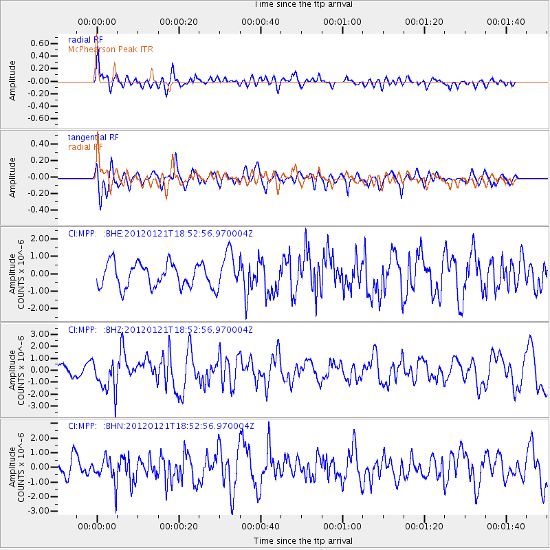
MPP McPhearson Peak - Earthquake Result Viewer
*The percent match for this event was below the threshold and hence no stack was calculated.
| Earthquake location: |
Near Coast Of Chiapas, Mexico |
| Earthquake latitude/longitude: |
14.9/-93.0 |
| Earthquake time(UTC): |
2012/01/21 (021) 18:47:11 GMT |
| Earthquake Depth: |
45 km |
| Earthquake Magnitude: |
5.9 MB, 5.8 MS, 6.2 MW, 6.3 MW |
| Earthquake Catalog/Contributor: |
WHDF/NEIC |
|
| Network: |
CI Caltech Regional Seismic Network |
| Station: |
MPP McPhearson Peak |
| Lat/Lon: |
34.89 N/119.81 W |
| Elevation: |
1739 m |
|
| Distance: |
31.3 deg |
| Az: |
314.427 deg |
| Baz: |
122.861 deg |
| Ray Param: |
$rayparam |
*The percent match for this event was below the threshold and hence was not used in the summary stack. |
|
| Radial Match: |
68.55355 % |
| Radial Bump: |
400 |
| Transverse Match: |
53.570225 % |
| Transverse Bump: |
400 |
| SOD ConfigId: |
436445 |
| Insert Time: |
2012-04-05 15:19:51.948 +0000 |
| GWidth: |
2.5 |
| Max Bumps: |
400 |
| Tol: |
0.001 |
|
Signal To Noise
| Channel | StoN | STA | LTA |
| CI:MPP: :BHZ:20120121T18:52:56.970004Z | 2.9594007 | 1.3654866E-6 | 4.6140647E-7 |
| CI:MPP: :BHN:20120121T18:52:56.970004Z | 1.4035146 | 9.2230783E-7 | 6.5714164E-7 |
| CI:MPP: :BHE:20120121T18:52:56.970004Z | 1.5818442 | 1.0671603E-6 | 6.746304E-7 |
| Arrivals |
| Ps | |
| PpPs | |
| PsPs/PpSs | |


