You are here: Home > Network List > G - GEOSCOPE Stations List
> Station TAM Tamanrasset, Algeria > Earthquake Result Viewer
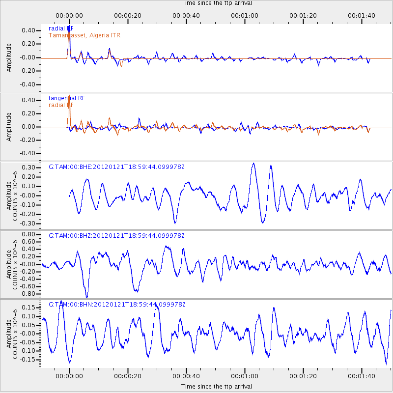
TAM Tamanrasset, Algeria - Earthquake Result Viewer
*The percent match for this event was below the threshold and hence no stack was calculated.
| Earthquake location: |
Near Coast Of Chiapas, Mexico |
| Earthquake latitude/longitude: |
14.9/-93.0 |
| Earthquake time(UTC): |
2012/01/21 (021) 18:47:11 GMT |
| Earthquake Depth: |
45 km |
| Earthquake Magnitude: |
5.9 MB, 5.8 MS, 6.2 MW, 6.3 MW |
| Earthquake Catalog/Contributor: |
WHDF/NEIC |
|
| Network: |
G GEOSCOPE |
| Station: |
TAM Tamanrasset, Algeria |
| Lat/Lon: |
22.79 N/5.53 E |
| Elevation: |
1377 m |
|
| Distance: |
92.0 deg |
| Az: |
65.947 deg |
| Baz: |
286.907 deg |
| Ray Param: |
$rayparam |
*The percent match for this event was below the threshold and hence was not used in the summary stack. |
|
| Radial Match: |
74.25009 % |
| Radial Bump: |
331 |
| Transverse Match: |
57.767883 % |
| Transverse Bump: |
369 |
| SOD ConfigId: |
436445 |
| Insert Time: |
2012-04-05 15:20:35.509 +0000 |
| GWidth: |
2.5 |
| Max Bumps: |
400 |
| Tol: |
0.001 |
|
Signal To Noise
| Channel | StoN | STA | LTA |
| G:TAM:00:BHZ:20120121T18:59:44.099978Z | 3.1218781 | 1.9206634E-7 | 6.152269E-8 |
| G:TAM:00:BHN:20120121T18:59:44.099978Z | 1.3862362 | 8.956639E-8 | 6.461121E-8 |
| G:TAM:00:BHE:20120121T18:59:44.099978Z | 0.8283207 | 7.273775E-8 | 8.781352E-8 |
| Arrivals |
| Ps | |
| PpPs | |
| PsPs/PpSs | |


