You are here: Home > Network List > UW - Pacific Northwest Regional Seismic Network Stations List
> Station MRBL Marblemount, WA, USA > Earthquake Result Viewer
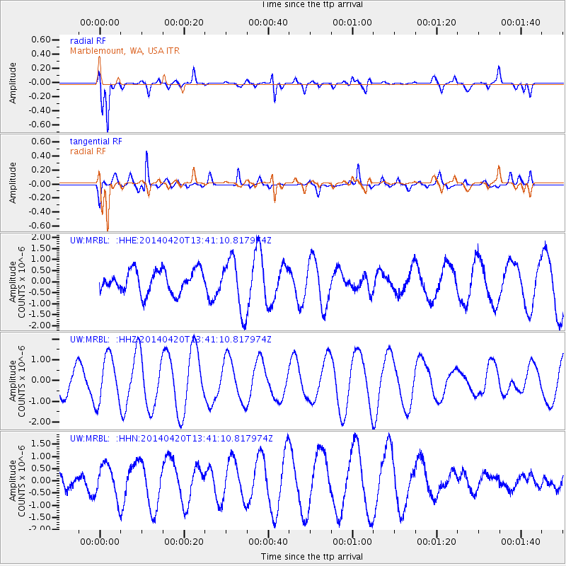
MRBL Marblemount, WA, USA - Earthquake Result Viewer
*The percent match for this event was below the threshold and hence no stack was calculated.
| Earthquake location: |
Solomon Islands |
| Earthquake latitude/longitude: |
-6.9/154.8 |
| Earthquake time(UTC): |
2014/04/20 (110) 13:28:42 GMT |
| Earthquake Depth: |
41 km |
| Earthquake Magnitude: |
5.2 MW |
| Earthquake Catalog/Contributor: |
ISC/ISC |
|
| Network: |
UW Pacific Northwest Regional Seismic Network |
| Station: |
MRBL Marblemount, WA, USA |
| Lat/Lon: |
48.52 N/121.48 W |
| Elevation: |
75 m |
|
| Distance: |
91.0 deg |
| Az: |
41.379 deg |
| Baz: |
260.795 deg |
| Ray Param: |
$rayparam |
*The percent match for this event was below the threshold and hence was not used in the summary stack. |
|
| Radial Match: |
79.23395 % |
| Radial Bump: |
385 |
| Transverse Match: |
72.16782 % |
| Transverse Bump: |
358 |
| SOD ConfigId: |
3390531 |
| Insert Time: |
2019-04-11 13:27:20.120 +0000 |
| GWidth: |
2.5 |
| Max Bumps: |
400 |
| Tol: |
0.001 |
|
Signal To Noise
| Channel | StoN | STA | LTA |
| UW:MRBL: :HHZ:20140420T13:41:10.817974Z | 1.5648627 | 1.1189636E-6 | 7.150554E-7 |
| UW:MRBL: :HHN:20140420T13:41:10.817974Z | 1.5320786 | 6.868674E-7 | 4.4832382E-7 |
| UW:MRBL: :HHE:20140420T13:41:10.817974Z | 2.428037 | 1.2191823E-6 | 5.0212674E-7 |
| Arrivals |
| Ps | |
| PpPs | |
| PsPs/PpSs | |


