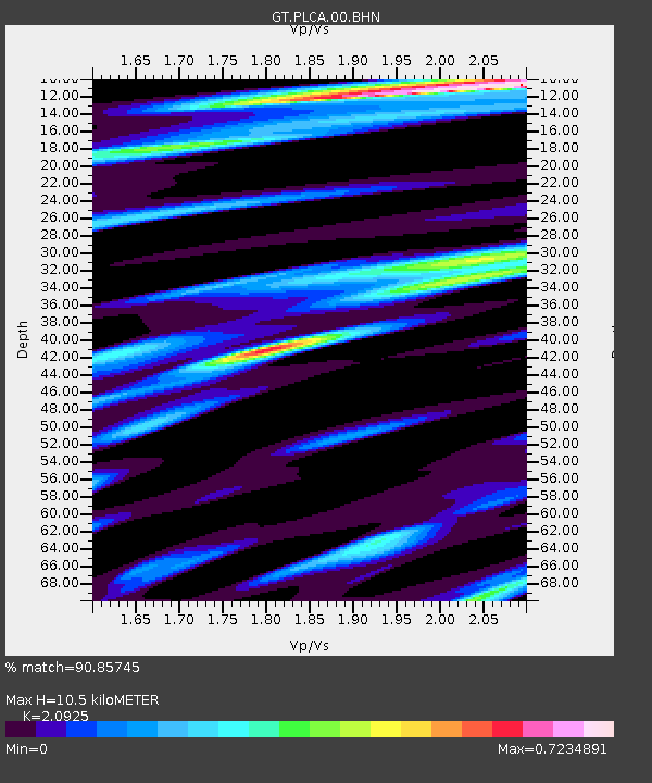
PLCA Paso Flores, Argentina - Earthquake Result Viewer
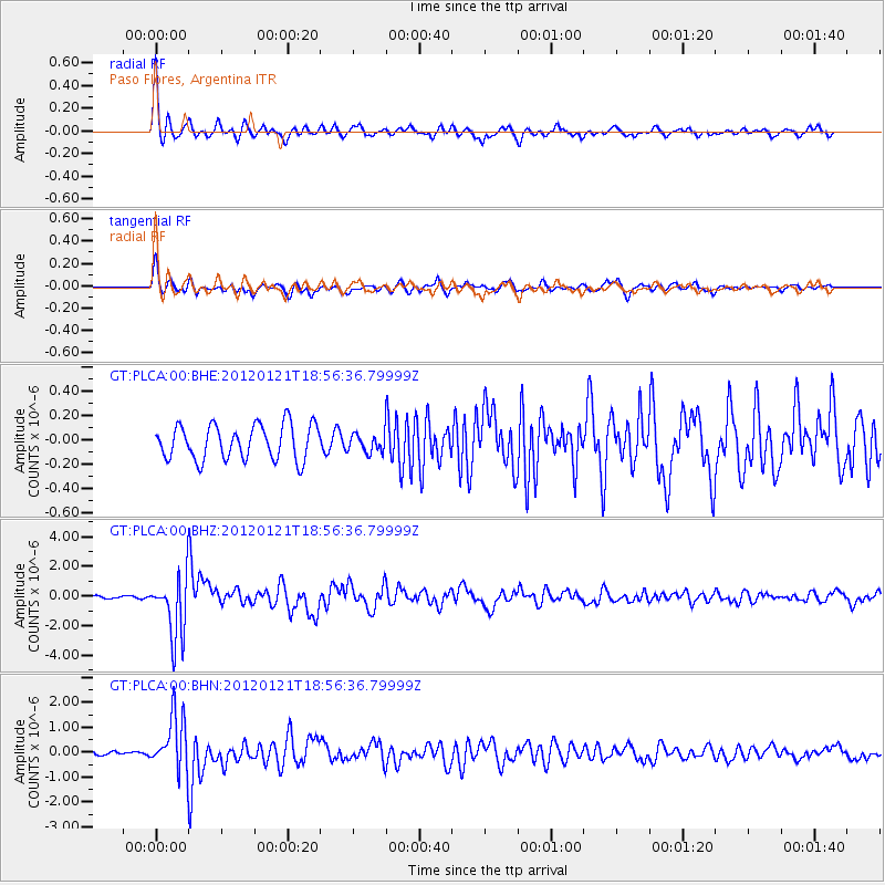
Earthquake location: Near Coast Of Chiapas, Mexico
Earthquake latitude/longitude: 14.9/-93.0
Earthquake time(UTC): 2012/01/21 (021) 18:47:11 GMT
Earthquake Depth: 45 km
Earthquake Magnitude: 5.9 MB, 5.8 MS, 6.2 MW, 6.3 MW
Earthquake Catalog/Contributor: WHDF/NEIC
Network: GT Global Telemetered Seismograph Network (USAF/USGS)
Station: PLCA Paso Flores, Argentina
Lat/Lon: 40.73 S/70.55 W
Elevation: 1050 m
Distance: 59.1 deg
Az: 160.233 deg
Baz: 334.512 deg
Ray Param: 0.06230248
Estimated Moho Depth: 10.5 km
Estimated Crust Vp/Vs: 2.09
Assumed Crust Vp: 6.597 km/s
Estimated Crust Vs: 3.153 km/s
Estimated Crust Poisson's Ratio: 0.35
Radial Match: 90.85745 %
Radial Bump: 339
Transverse Match: 82.52971 %
Transverse Bump: 343
SOD ConfigId: 436445
Insert Time: 2012-04-05 15:21:16.918 +0000
GWidth: 2.5
Max Bumps: 400
Tol: 0.001

Signal To Noise

ChannelStoNSTALTA
GT:PLCA:00:BHZ:20120121T18:56:36.79999Z19.8232672.108069E-61.0634317E-7
GT:PLCA:00:BHN:20120121T18:56:36.79999Z13.091611.1028859E-68.4243716E-8
GT:PLCA:00:BHE:20120121T18:56:36.79999Z0.53887427.672404E-81.4237838E-7
Arrivals
Ps1.8 SECOND
PpPs4.7 SECOND
PsPs/PpSs6.5 SECOND