You are here: Home > Network List > UW - Pacific Northwest Regional Seismic Network Stations List
> Station UMAT Pilot Rock, OR, USA > Earthquake Result Viewer
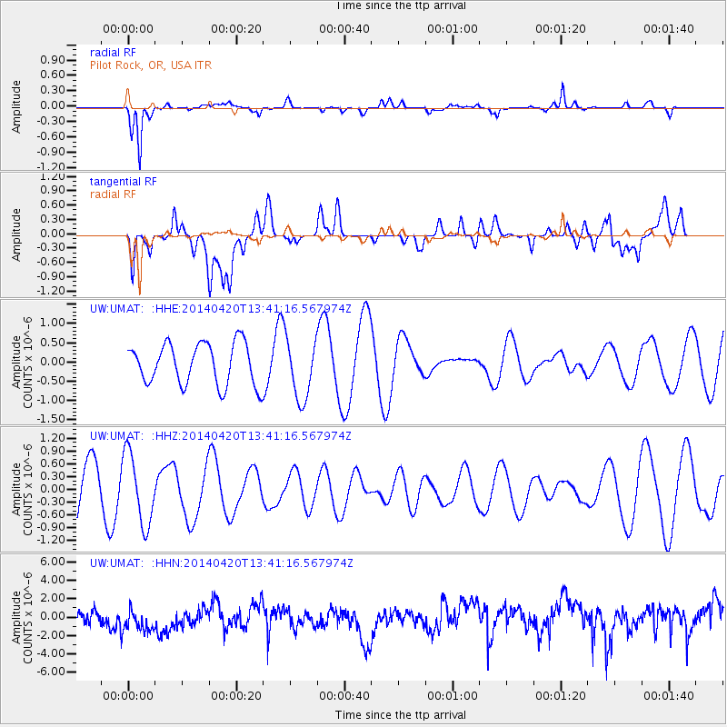
UMAT Pilot Rock, OR, USA - Earthquake Result Viewer
*The percent match for this event was below the threshold and hence no stack was calculated.
| Earthquake location: |
Solomon Islands |
| Earthquake latitude/longitude: |
-6.9/154.8 |
| Earthquake time(UTC): |
2014/04/20 (110) 13:28:42 GMT |
| Earthquake Depth: |
41 km |
| Earthquake Magnitude: |
5.2 MW |
| Earthquake Catalog/Contributor: |
ISC/ISC |
|
| Network: |
UW Pacific Northwest Regional Seismic Network |
| Station: |
UMAT Pilot Rock, OR, USA |
| Lat/Lon: |
45.29 N/118.96 W |
| Elevation: |
1318 m |
|
| Distance: |
92.2 deg |
| Az: |
44.826 deg |
| Baz: |
262.536 deg |
| Ray Param: |
$rayparam |
*The percent match for this event was below the threshold and hence was not used in the summary stack. |
|
| Radial Match: |
79.79461 % |
| Radial Bump: |
345 |
| Transverse Match: |
31.242847 % |
| Transverse Bump: |
400 |
| SOD ConfigId: |
3390531 |
| Insert Time: |
2019-04-11 13:27:23.998 +0000 |
| GWidth: |
2.5 |
| Max Bumps: |
400 |
| Tol: |
0.001 |
|
Signal To Noise
| Channel | StoN | STA | LTA |
| UW:UMAT: :HHZ:20140420T13:41:16.567974Z | 1.2192684 | 8.375334E-7 | 6.869147E-7 |
| UW:UMAT: :HHN:20140420T13:41:16.567974Z | 1.2988349 | 1.6521108E-6 | 1.2719944E-6 |
| UW:UMAT: :HHE:20140420T13:41:16.567974Z | 1.4558966 | 7.7705903E-7 | 5.3373225E-7 |
| Arrivals |
| Ps | |
| PpPs | |
| PsPs/PpSs | |


