You are here: Home > Network List > TA - USArray Transportable Network (new EarthScope stations) Stations List
> Station K02D Willamette Meridian, OR, USA > Earthquake Result Viewer
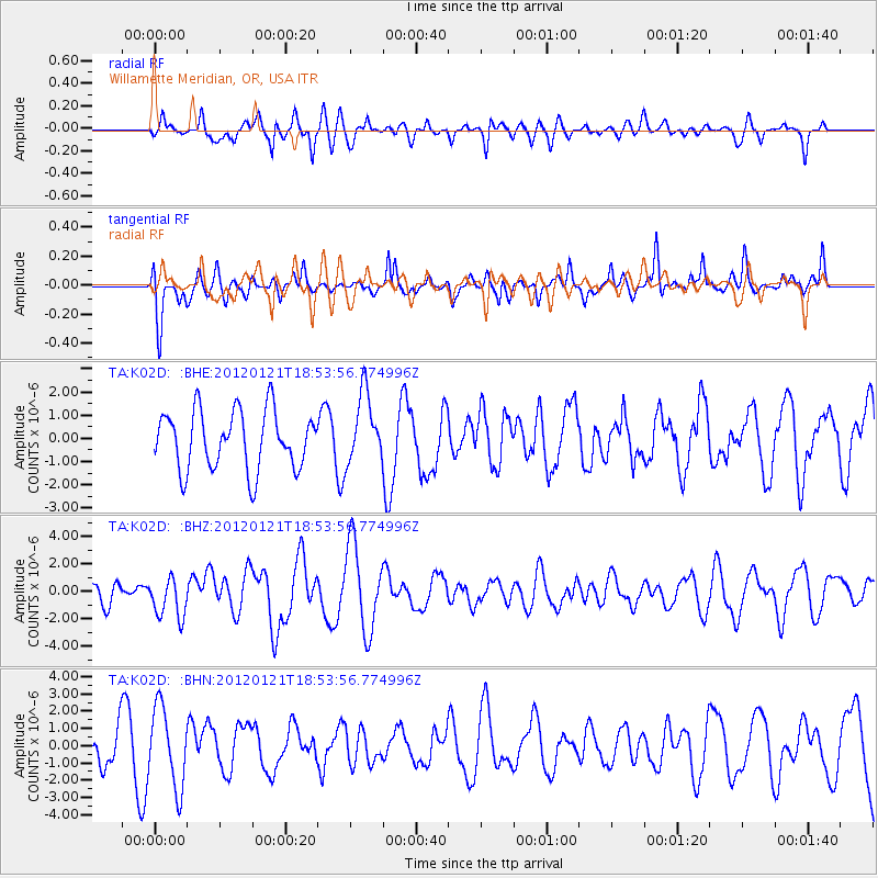
K02D Willamette Meridian, OR, USA - Earthquake Result Viewer
*The percent match for this event was below the threshold and hence no stack was calculated.
| Earthquake location: |
Near Coast Of Chiapas, Mexico |
| Earthquake latitude/longitude: |
14.9/-93.0 |
| Earthquake time(UTC): |
2012/01/21 (021) 18:47:11 GMT |
| Earthquake Depth: |
45 km |
| Earthquake Magnitude: |
5.9 MB, 5.8 MS, 6.2 MW, 6.3 MW |
| Earthquake Catalog/Contributor: |
WHDF/NEIC |
|
| Network: |
TA USArray Transportable Network (new EarthScope stations) |
| Station: |
K02D Willamette Meridian, OR, USA |
| Lat/Lon: |
42.70 N/123.67 W |
| Elevation: |
989 m |
|
| Distance: |
38.2 deg |
| Az: |
322.589 deg |
| Baz: |
127.174 deg |
| Ray Param: |
$rayparam |
*The percent match for this event was below the threshold and hence was not used in the summary stack. |
|
| Radial Match: |
58.741962 % |
| Radial Bump: |
400 |
| Transverse Match: |
67.68219 % |
| Transverse Bump: |
400 |
| SOD ConfigId: |
436445 |
| Insert Time: |
2012-04-05 15:24:56.975 +0000 |
| GWidth: |
2.5 |
| Max Bumps: |
400 |
| Tol: |
0.001 |
|
Signal To Noise
| Channel | StoN | STA | LTA |
| TA:K02D: :BHZ:20120121T18:53:56.774996Z | 1.024813 | 1.4429827E-6 | 1.4080448E-6 |
| TA:K02D: :BHN:20120121T18:53:56.774996Z | 2.4425507 | 2.2941506E-6 | 9.392439E-7 |
| TA:K02D: :BHE:20120121T18:53:56.774996Z | 1.1969098 | 1.5056089E-6 | 1.2579134E-6 |
| Arrivals |
| Ps | |
| PpPs | |
| PsPs/PpSs | |


