You are here: Home > Network List > UW - Pacific Northwest Regional Seismic Network Stations List
> Station LTY Liberty (broad-band) > Earthquake Result Viewer
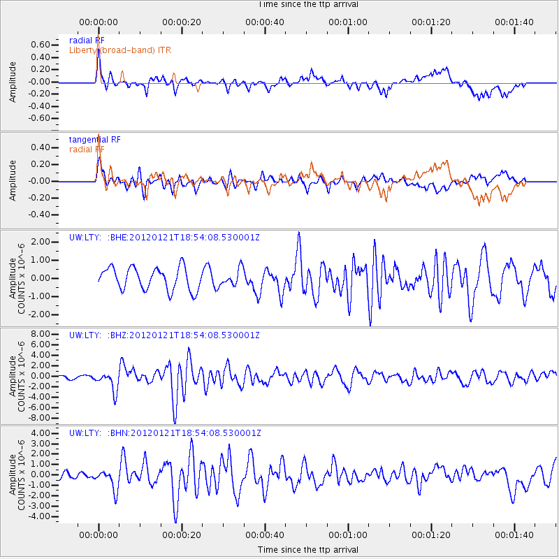
LTY Liberty (broad-band) - Earthquake Result Viewer
*The percent match for this event was below the threshold and hence no stack was calculated.
| Earthquake location: |
Near Coast Of Chiapas, Mexico |
| Earthquake latitude/longitude: |
14.9/-93.0 |
| Earthquake time(UTC): |
2012/01/21 (021) 18:47:11 GMT |
| Earthquake Depth: |
45 km |
| Earthquake Magnitude: |
5.9 MB, 5.8 MS, 6.2 MW, 6.3 MW |
| Earthquake Catalog/Contributor: |
WHDF/NEIC |
|
| Network: |
UW Pacific Northwest Regional Seismic Network |
| Station: |
LTY Liberty (broad-band) |
| Lat/Lon: |
47.26 N/120.66 W |
| Elevation: |
970 m |
|
| Distance: |
39.6 deg |
| Az: |
330.283 deg |
| Baz: |
135.278 deg |
| Ray Param: |
$rayparam |
*The percent match for this event was below the threshold and hence was not used in the summary stack. |
|
| Radial Match: |
72.58669 % |
| Radial Bump: |
400 |
| Transverse Match: |
67.56686 % |
| Transverse Bump: |
400 |
| SOD ConfigId: |
436445 |
| Insert Time: |
2012-04-05 15:28:44.033 +0000 |
| GWidth: |
2.5 |
| Max Bumps: |
400 |
| Tol: |
0.001 |
|
Signal To Noise
| Channel | StoN | STA | LTA |
| UW:LTY: :BHZ:20120121T18:54:08.530001Z | 6.9102383 | 1.8569609E-6 | 2.6872604E-7 |
| UW:LTY: :BHN:20120121T18:54:08.530001Z | 2.536557 | 9.897946E-7 | 3.9021185E-7 |
| UW:LTY: :BHE:20120121T18:54:08.530001Z | 0.73270446 | 4.4876364E-7 | 6.124757E-7 |
| Arrivals |
| Ps | |
| PpPs | |
| PsPs/PpSs | |


