You are here: Home > Network List > UW - Pacific Northwest Regional Seismic Network Stations List
> Station MRBL Marblemount, WA, USA > Earthquake Result Viewer
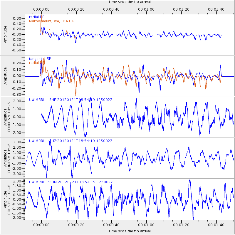
MRBL Marblemount, WA, USA - Earthquake Result Viewer
*The percent match for this event was below the threshold and hence no stack was calculated.
| Earthquake location: |
Near Coast Of Chiapas, Mexico |
| Earthquake latitude/longitude: |
14.9/-93.0 |
| Earthquake time(UTC): |
2012/01/21 (021) 18:47:11 GMT |
| Earthquake Depth: |
45 km |
| Earthquake Magnitude: |
5.9 MB, 5.8 MS, 6.2 MW, 6.3 MW |
| Earthquake Catalog/Contributor: |
WHDF/NEIC |
|
| Network: |
UW Pacific Northwest Regional Seismic Network |
| Station: |
MRBL Marblemount, WA, USA |
| Lat/Lon: |
48.52 N/121.48 W |
| Elevation: |
75 m |
|
| Distance: |
40.9 deg |
| Az: |
331.052 deg |
| Baz: |
135.259 deg |
| Ray Param: |
$rayparam |
*The percent match for this event was below the threshold and hence was not used in the summary stack. |
|
| Radial Match: |
64.41597 % |
| Radial Bump: |
400 |
| Transverse Match: |
40.204163 % |
| Transverse Bump: |
400 |
| SOD ConfigId: |
436445 |
| Insert Time: |
2012-04-05 15:28:57.267 +0000 |
| GWidth: |
2.5 |
| Max Bumps: |
400 |
| Tol: |
0.001 |
|
Signal To Noise
| Channel | StoN | STA | LTA |
| UW:MRBL: :BHZ:20120121T18:54:19.125002Z | 2.4531655 | 1.8069574E-6 | 7.3658185E-7 |
| UW:MRBL: :BHN:20120121T18:54:19.125002Z | 2.346139 | 8.924345E-7 | 3.8038434E-7 |
| UW:MRBL: :BHE:20120121T18:54:19.125002Z | 0.97710896 | 1.059939E-6 | 1.0847705E-6 |
| Arrivals |
| Ps | |
| PpPs | |
| PsPs/PpSs | |


