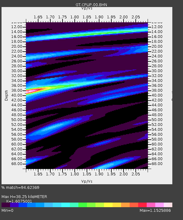
CPUP Villa Florida, Paraguay - Earthquake Result Viewer

Earthquake location: South Sandwich Islands Region
Earthquake latitude/longitude: -56.8/-25.1
Earthquake time(UTC): 2012/01/22 (022) 05:53:42 GMT
Earthquake Depth: 13 km
Earthquake Magnitude: 5.5 MB, 6.1 MS, 6.0 MW, 6.0 MW
Earthquake Catalog/Contributor: WHDF/NEIC
Network: GT Global Telemetered Seismograph Network (USAF/USGS)
Station: CPUP Villa Florida, Paraguay
Lat/Lon: 26.33 S/57.33 W
Elevation: 105 m
Distance: 38.1 deg
Az: 309.283 deg
Baz: 151.64 deg
Ray Param: 0.07572777
Estimated Moho Depth: 38.25 km
Estimated Crust Vp/Vs: 1.61
Assumed Crust Vp: 6.498 km/s
Estimated Crust Vs: 4.042 km/s
Estimated Crust Poisson's Ratio: 0.18
Radial Match: 94.62369 %
Radial Bump: 330
Transverse Match: 58.91242 %
Transverse Bump: 400
SOD ConfigId: 436445
Insert Time: 2012-04-05 15:33:08.190 +0000
GWidth: 2.5
Max Bumps: 400
Tol: 0.001

Signal To Noise

ChannelStoNSTALTA
GT:CPUP:00:BHZ:20120122T06:00:30.025007Z10.5107846.5068E-76.190594E-8
GT:CPUP:00:BHN:20120122T06:00:30.025007Z6.91631273.9882696E-75.766468E-8
GT:CPUP:00:BHE:20120122T06:00:30.025007Z3.43733862.249177E-76.5433674E-8
Arrivals
Ps3.9 SECOND
PpPs14 SECOND
PsPs/PpSs18 SECOND