You are here: Home > Network List > TA - USArray Transportable Network (new EarthScope stations) Stations List
> Station 833A Chaparral WMA, Artesia Wells, TX, USA > Earthquake Result Viewer
833A Chaparral WMA, Artesia Wells, TX, USA - Earthquake Result Viewer
| Earthquake location: |
Near Coast Of Central Chile |
| Earthquake latitude/longitude: |
-36.4/-73.0 |
| Earthquake time(UTC): |
2012/01/23 (023) 16:04:52 GMT |
| Earthquake Depth: |
20 km |
| Earthquake Magnitude: |
5.8 MB, 6.0 MS, 6.1 MW, 6.2 MW |
| Earthquake Catalog/Contributor: |
WHDF/NEIC |
|
| Network: |
TA USArray Transportable Network (new EarthScope stations) |
| Station: |
833A Chaparral WMA, Artesia Wells, TX, USA |
| Lat/Lon: |
28.32 N/99.39 W |
| Elevation: |
171 m |
|
| Distance: |
69.0 deg |
| Az: |
335.207 deg |
| Baz: |
157.437 deg |
| Ray Param: |
0.05591302 |
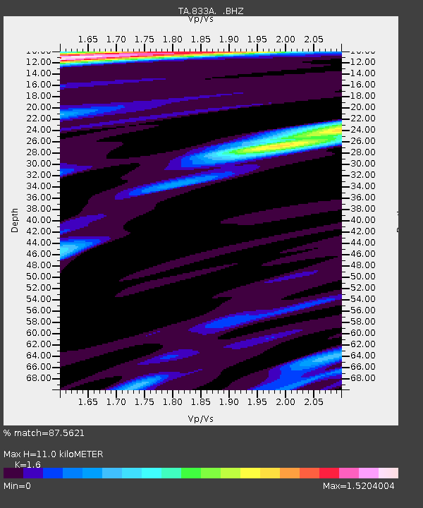
| Estimated Moho Depth: |
11.0 km |
| Estimated Crust Vp/Vs: |
1.60 |
| Assumed Crust Vp: |
6.347 km/s |
| Estimated Crust Vs: |
3.967 km/s |
| Estimated Crust Poisson's Ratio: |
0.18 |
|
| Radial Match: |
87.5621 % |
| Radial Bump: |
394 |
| Transverse Match: |
71.87252 % |
| Transverse Bump: |
389 |
| SOD ConfigId: |
436445 |
| Insert Time: |
2012-04-05 15:52:41.437 +0000 |
| GWidth: |
2.5 |
| Max Bumps: |
400 |
| Tol: |
0.001 |
|

Signal To Noise
| Channel | StoN | STA | LTA |
| TA:833A: :BHZ:20120123T16:15:25.774983Z | 6.555564 | 1.2281707E-6 | 1.8734785E-7 |
| TA:833A: :BHN:20120123T16:15:25.774983Z | 1.9692606 | 3.1567347E-7 | 1.603005E-7 |
| TA:833A: :BHE:20120123T16:15:25.774983Z | 0.82296306 | 1.5985785E-7 | 1.9424668E-7 |
| Arrivals |
| Ps | 1.1 SECOND |
| PpPs | 4.3 SECOND |
| PsPs/PpSs | 5.4 SECOND |


