You are here: Home > Network List > TA - USArray Transportable Network (new EarthScope stations) Stations List
> Station V36A Jenks, OK, USA > Earthquake Result Viewer
V36A Jenks, OK, USA - Earthquake Result Viewer
| Earthquake location: |
Near Coast Of Central Chile |
| Earthquake latitude/longitude: |
-36.4/-73.0 |
| Earthquake time(UTC): |
2012/01/23 (023) 16:04:52 GMT |
| Earthquake Depth: |
20 km |
| Earthquake Magnitude: |
5.8 MB, 6.0 MS, 6.1 MW, 6.2 MW |
| Earthquake Catalog/Contributor: |
WHDF/NEIC |
|
| Network: |
TA USArray Transportable Network (new EarthScope stations) |
| Station: |
V36A Jenks, OK, USA |
| Lat/Lon: |
35.79 N/95.94 W |
| Elevation: |
236 m |
|
| Distance: |
74.9 deg |
| Az: |
340.863 deg |
| Baz: |
161.018 deg |
| Ray Param: |
0.05198752 |
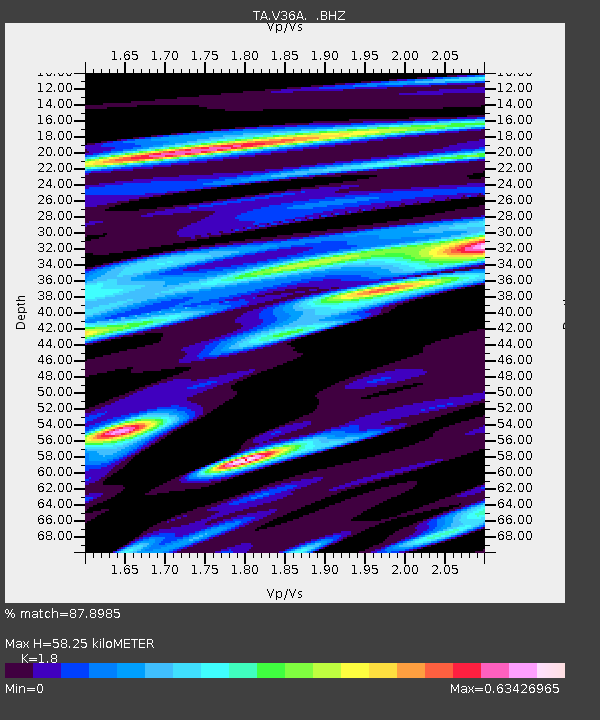
| Estimated Moho Depth: |
58.25 km |
| Estimated Crust Vp/Vs: |
1.80 |
| Assumed Crust Vp: |
6.498 km/s |
| Estimated Crust Vs: |
3.61 km/s |
| Estimated Crust Poisson's Ratio: |
0.28 |
|
| Radial Match: |
87.8985 % |
| Radial Bump: |
338 |
| Transverse Match: |
53.43938 % |
| Transverse Bump: |
393 |
| SOD ConfigId: |
436445 |
| Insert Time: |
2012-04-05 15:56:44.047 +0000 |
| GWidth: |
2.5 |
| Max Bumps: |
400 |
| Tol: |
0.001 |
|
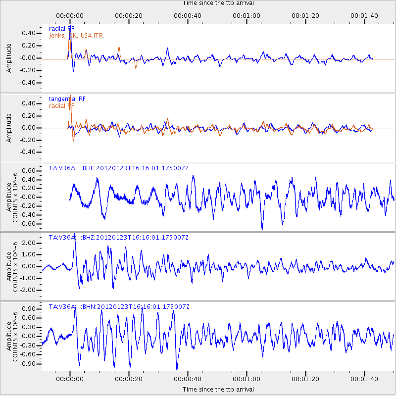
Signal To Noise
| Channel | StoN | STA | LTA |
| TA:V36A: :BHZ:20120123T16:16:01.175007Z | 5.521451 | 1.0994219E-6 | 1.9911829E-7 |
| TA:V36A: :BHN:20120123T16:16:01.175007Z | 4.039845 | 4.767432E-7 | 1.1801027E-7 |
| TA:V36A: :BHE:20120123T16:16:01.175007Z | 1.0077355 | 1.8614226E-7 | 1.8471341E-7 |
| Arrivals |
| Ps | 7.4 SECOND |
| PpPs | 24 SECOND |
| PsPs/PpSs | 32 SECOND |


