You are here: Home > Network List > TA - USArray Transportable Network (new EarthScope stations) Stations List
> Station O37A Wolven Farm, McFall, MO, USA > Earthquake Result Viewer
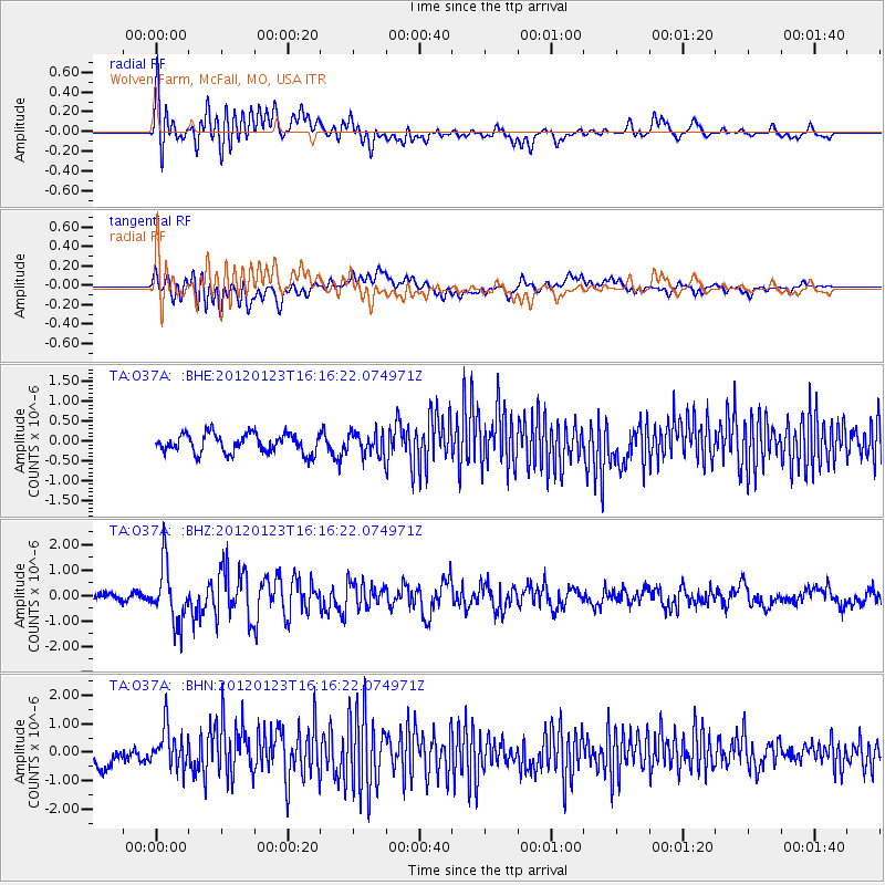
O37A Wolven Farm, McFall, MO, USA - Earthquake Result Viewer
*The percent match for this event was below the threshold and hence no stack was calculated.
| Earthquake location: |
Near Coast Of Central Chile |
| Earthquake latitude/longitude: |
-36.4/-73.0 |
| Earthquake time(UTC): |
2012/01/23 (023) 16:04:52 GMT |
| Earthquake Depth: |
20 km |
| Earthquake Magnitude: |
5.8 MB, 6.0 MS, 6.1 MW, 6.2 MW |
| Earthquake Catalog/Contributor: |
WHDF/NEIC |
|
| Network: |
TA USArray Transportable Network (new EarthScope stations) |
| Station: |
O37A Wolven Farm, McFall, MO, USA |
| Lat/Lon: |
40.17 N/94.15 W |
| Elevation: |
284 m |
|
| Distance: |
78.6 deg |
| Az: |
343.645 deg |
| Baz: |
162.757 deg |
| Ray Param: |
$rayparam |
*The percent match for this event was below the threshold and hence was not used in the summary stack. |
|
| Radial Match: |
68.50347 % |
| Radial Bump: |
400 |
| Transverse Match: |
64.04326 % |
| Transverse Bump: |
400 |
| SOD ConfigId: |
436445 |
| Insert Time: |
2012-04-05 16:07:00.210 +0000 |
| GWidth: |
2.5 |
| Max Bumps: |
400 |
| Tol: |
0.001 |
|
Signal To Noise
| Channel | StoN | STA | LTA |
| TA:O37A: :BHZ:20120123T16:16:22.074971Z | 6.139311 | 1.1242429E-6 | 1.83122E-7 |
| TA:O37A: :BHN:20120123T16:16:22.074971Z | 2.0990155 | 7.0099367E-7 | 3.339631E-7 |
| TA:O37A: :BHE:20120123T16:16:22.074971Z | 1.2255458 | 2.965984E-7 | 2.420133E-7 |
| Arrivals |
| Ps | |
| PpPs | |
| PsPs/PpSs | |


