You are here: Home > Network List > TA - USArray Transportable Network (new EarthScope stations) Stations List
> Station Z47A Carrollton, AL, USA > Earthquake Result Viewer
Z47A Carrollton, AL, USA - Earthquake Result Viewer
| Earthquake location: |
Near Coast Of Central Chile |
| Earthquake latitude/longitude: |
-36.4/-73.0 |
| Earthquake time(UTC): |
2012/01/23 (023) 16:04:52 GMT |
| Earthquake Depth: |
20 km |
| Earthquake Magnitude: |
5.8 MB, 6.0 MS, 6.1 MW, 6.2 MW |
| Earthquake Catalog/Contributor: |
WHDF/NEIC |
|
| Network: |
TA USArray Transportable Network (new EarthScope stations) |
| Station: |
Z47A Carrollton, AL, USA |
| Lat/Lon: |
33.20 N/88.07 W |
| Elevation: |
65 m |
|
| Distance: |
70.7 deg |
| Az: |
346.669 deg |
| Baz: |
167.183 deg |
| Ray Param: |
0.05481481 |
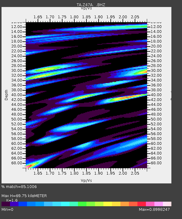
| Estimated Moho Depth: |
69.75 km |
| Estimated Crust Vp/Vs: |
1.60 |
| Assumed Crust Vp: |
6.201 km/s |
| Estimated Crust Vs: |
3.876 km/s |
| Estimated Crust Poisson's Ratio: |
0.18 |
|
| Radial Match: |
85.1006 % |
| Radial Bump: |
400 |
| Transverse Match: |
73.874695 % |
| Transverse Bump: |
400 |
| SOD ConfigId: |
436445 |
| Insert Time: |
2012-04-05 16:14:51.402 +0000 |
| GWidth: |
2.5 |
| Max Bumps: |
400 |
| Tol: |
0.001 |
|
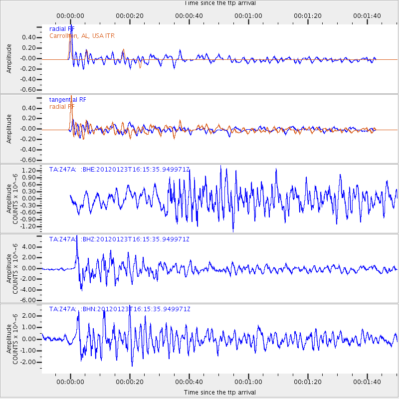
Signal To Noise
| Channel | StoN | STA | LTA |
| TA:Z47A: :BHZ:20120123T16:15:35.949971Z | 10.256754 | 1.9851493E-6 | 1.9354557E-7 |
| TA:Z47A: :BHN:20120123T16:15:35.949971Z | 3.7939494 | 9.534205E-7 | 2.5130026E-7 |
| TA:Z47A: :BHE:20120123T16:15:35.949971Z | 1.4919626 | 4.17666E-7 | 2.79944E-7 |
| Arrivals |
| Ps | 7.0 SECOND |
| PpPs | 28 SECOND |
| PsPs/PpSs | 35 SECOND |


