You are here: Home > Network List > TA - USArray Transportable Network (new EarthScope stations) Stations List
> Station Z46A Louisville, MS, USA > Earthquake Result Viewer
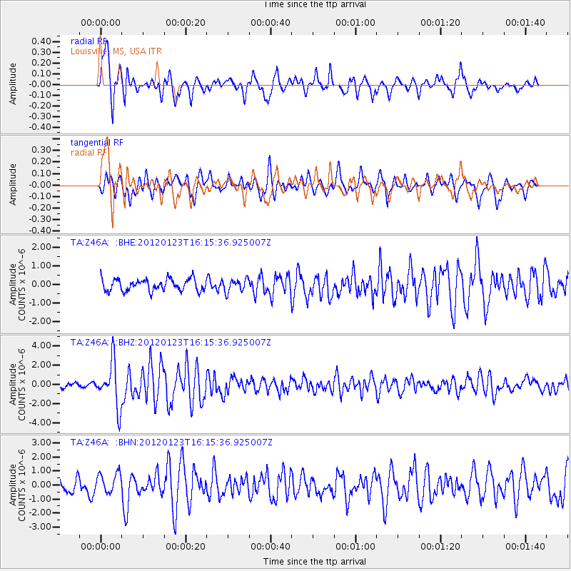
Z46A Louisville, MS, USA - Earthquake Result Viewer
*The percent match for this event was below the threshold and hence no stack was calculated.
| Earthquake location: |
Near Coast Of Central Chile |
| Earthquake latitude/longitude: |
-36.4/-73.0 |
| Earthquake time(UTC): |
2012/01/23 (023) 16:04:52 GMT |
| Earthquake Depth: |
20 km |
| Earthquake Magnitude: |
5.8 MB, 6.0 MS, 6.1 MW, 6.2 MW |
| Earthquake Catalog/Contributor: |
WHDF/NEIC |
|
| Network: |
TA USArray Transportable Network (new EarthScope stations) |
| Station: |
Z46A Louisville, MS, USA |
| Lat/Lon: |
33.19 N/88.94 W |
| Elevation: |
125 m |
|
| Distance: |
70.8 deg |
| Az: |
345.914 deg |
| Baz: |
166.458 deg |
| Ray Param: |
$rayparam |
*The percent match for this event was below the threshold and hence was not used in the summary stack. |
|
| Radial Match: |
80.464134 % |
| Radial Bump: |
400 |
| Transverse Match: |
79.38688 % |
| Transverse Bump: |
400 |
| SOD ConfigId: |
436445 |
| Insert Time: |
2012-04-05 16:15:16.302 +0000 |
| GWidth: |
2.5 |
| Max Bumps: |
400 |
| Tol: |
0.001 |
|
Signal To Noise
| Channel | StoN | STA | LTA |
| TA:Z46A: :BHZ:20120123T16:15:36.925007Z | 10.809877 | 2.3655036E-6 | 2.1882798E-7 |
| TA:Z46A: :BHN:20120123T16:15:36.925007Z | 1.6337823 | 7.1524806E-7 | 4.3778664E-7 |
| TA:Z46A: :BHE:20120123T16:15:36.925007Z | 1.0714525 | 3.3919224E-7 | 3.1657234E-7 |
| Arrivals |
| Ps | |
| PpPs | |
| PsPs/PpSs | |


