You are here: Home > Network List > TA - USArray Transportable Network (new EarthScope stations) Stations List
> Station X43A Marvell, AR, USA > Earthquake Result Viewer
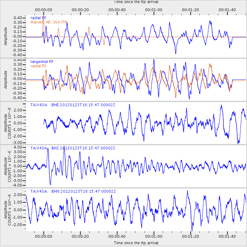
X43A Marvell, AR, USA - Earthquake Result Viewer
*The percent match for this event was below the threshold and hence no stack was calculated.
| Earthquake location: |
Near Coast Of Central Chile |
| Earthquake latitude/longitude: |
-36.4/-73.0 |
| Earthquake time(UTC): |
2012/01/23 (023) 16:04:52 GMT |
| Earthquake Depth: |
20 km |
| Earthquake Magnitude: |
5.8 MB, 6.0 MS, 6.1 MW, 6.2 MW |
| Earthquake Catalog/Contributor: |
WHDF/NEIC |
|
| Network: |
TA USArray Transportable Network (new EarthScope stations) |
| Station: |
X43A Marvell, AR, USA |
| Lat/Lon: |
34.52 N/90.88 W |
| Elevation: |
53 m |
|
| Distance: |
72.5 deg |
| Az: |
344.609 deg |
| Baz: |
164.972 deg |
| Ray Param: |
$rayparam |
*The percent match for this event was below the threshold and hence was not used in the summary stack. |
|
| Radial Match: |
59.1776 % |
| Radial Bump: |
384 |
| Transverse Match: |
68.30923 % |
| Transverse Bump: |
400 |
| SOD ConfigId: |
436445 |
| Insert Time: |
2012-04-05 16:16:31.546 +0000 |
| GWidth: |
2.5 |
| Max Bumps: |
400 |
| Tol: |
0.001 |
|
Signal To Noise
| Channel | StoN | STA | LTA |
| TA:X43A: :BHZ:20120123T16:15:47.00002Z | 5.9760423 | 1.8523519E-6 | 3.0996299E-7 |
| TA:X43A: :BHN:20120123T16:15:47.00002Z | 0.68868995 | 5.717542E-7 | 8.3020547E-7 |
| TA:X43A: :BHE:20120123T16:15:47.00002Z | 1.7241392 | 9.2844874E-7 | 5.384999E-7 |
| Arrivals |
| Ps | |
| PpPs | |
| PsPs/PpSs | |


