You are here: Home > Network List > TA - USArray Transportable Network (new EarthScope stations) Stations List
> Station R41A Rosebud, MO, USA > Earthquake Result Viewer
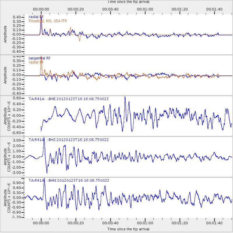
R41A Rosebud, MO, USA - Earthquake Result Viewer
*The percent match for this event was below the threshold and hence no stack was calculated.
| Earthquake location: |
Near Coast Of Central Chile |
| Earthquake latitude/longitude: |
-36.4/-73.0 |
| Earthquake time(UTC): |
2012/01/23 (023) 16:04:52 GMT |
| Earthquake Depth: |
20 km |
| Earthquake Magnitude: |
5.8 MB, 6.0 MS, 6.1 MW, 6.2 MW |
| Earthquake Catalog/Contributor: |
WHDF/NEIC |
|
| Network: |
TA USArray Transportable Network (new EarthScope stations) |
| Station: |
R41A Rosebud, MO, USA |
| Lat/Lon: |
38.30 N/91.38 W |
| Elevation: |
257 m |
|
| Distance: |
76.2 deg |
| Az: |
345.226 deg |
| Baz: |
164.844 deg |
| Ray Param: |
$rayparam |
*The percent match for this event was below the threshold and hence was not used in the summary stack. |
|
| Radial Match: |
78.14291 % |
| Radial Bump: |
400 |
| Transverse Match: |
57.443035 % |
| Transverse Bump: |
400 |
| SOD ConfigId: |
436445 |
| Insert Time: |
2012-04-05 16:18:52.254 +0000 |
| GWidth: |
2.5 |
| Max Bumps: |
400 |
| Tol: |
0.001 |
|
Signal To Noise
| Channel | StoN | STA | LTA |
| TA:R41A: :BHZ:20120123T16:16:08.75002Z | 8.59339 | 1.5718855E-6 | 1.8291797E-7 |
| TA:R41A: :BHN:20120123T16:16:08.75002Z | 3.305135 | 4.799528E-7 | 1.4521427E-7 |
| TA:R41A: :BHE:20120123T16:16:08.75002Z | 1.1498628 | 1.9142384E-7 | 1.6647537E-7 |
| Arrivals |
| Ps | |
| PpPs | |
| PsPs/PpSs | |


